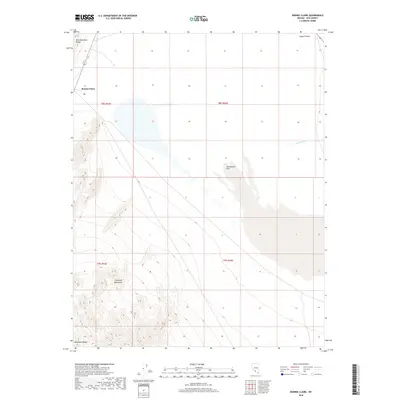
2018 Map of Bonnie Claire
USGS Topo · Published 2018About this map
Bonnie Claire stands as a focal point in this high-desert landscape of Nye County, where the topography is defined by significant elevation changes between the valley floor and the surrounding peaks. The map reveals the stark geography of Sarcobatus Flat, an expansive basin that contrasts with the rising slopes of the Gold Mountain Range to the northwest and the Grapevine Mountains to the southwest. This 2018 survey detail shows how modern infrastructure like Us-95 traverses the arid terrain, passing near the northern reach of the Amargosa Range. Surface water is scarce, marked only by intermittent features such as Tolicha Wash and the descriptive Coyote Holes, illustrating the remote and arid character of this portion of the Great Basin.
Find a feature on this map
12 named features on this map. Tap any name to fly to it.
Don’t see what you’re looking for? This feature index may not catch every label — zoom into the map to look around manually.
Map Details
Editions of this 2018 Bonnie Claire Map
This is the sole edition of this map. No revisions or reprints were ever made.
Other maps of this area

1908 · Kawich
USGS Topo · 1:250,000

1908 · Lida
USGS Topo · 1:250,000

1913 · Lida
USGS Topo · 1:250,000

1942 · Tolicha Peak
USGS Topo · 1:125,000

1954 · Goldfield
USGS Topo · 1:250,000

1955 · Goldfield
USGS Topo · 1:250,000

1958 · Goldfield
USGS Topo · 1:250,000

1962 · Goldfield
USGS Topo · 1:250,000
1966 · Springdale
USGS Topo · 1:62,500
1967 · Bonnie Claire SE
USGS Topo · 1:24,000