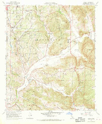
1968 Map of Bonsall
USGS Topo · Published 1970About this map
The San Luis Rey River carves a significant path through this portion of San Diego County, dictating the development of agriculture and small ranching communities in the late 1960s. The landscape is defined by the transition from the rolling hills of Fallbrook in the northwest to the rugged elevations of Monserate Mountain and Mt Ararat. This period shows a shift toward recreational development, with the Pala Mesa Golf Club and Fallbrook Country Club appearing alongside traditional agricultural sites like the Dulin Ranch and Circle R Ranch. Educational infrastructure is well-established, including the Fallbrook Union High Sch and Bonsall Union Sch. Significant transport and utility features, such as the Fallbrook Community Air Park and various gaging and pumping stations, highlight the area's growth as a suburban and rural hub before the intensification of modern coastal development.
Find a feature on this map
43 named features on this map. Tap any name to fly to it.
Don’t see what you’re looking for? This feature index may not catch every label — zoom into the map to look around manually.
Map Details
Editions of this 1968 Bonsall Map
3 editions found
Other maps of this area

1893 · Oceanside
USGS Topo · 1:62,500

1893 · Escondido
USGS Topo · 1:62,500

1898 · Oceanside
USGS Topo · 1:62,500

1901 · Escondido
USGS Topo · 1:62,500

1901 · Oceanside
USGS Topo · 1:62,500

1901 · San Luis Rey
USGS Topo · 1:125,000

1904 · Southern California Sheet No. 2
USGS Topo · 1:250,000

1941 · Margarita Peak
USGS Topo · 1:62,500

1942 · Margarita Peak
USGS Topo · 1:62,500

1942 · Temecula
USGS Topo · 1:62,500