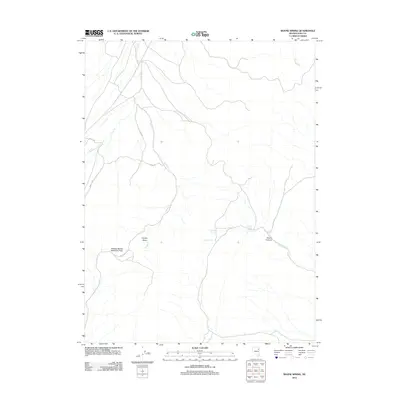
2012 Map of Boone Spring
USGS Topo · Published 2012About this map
Boone Spring and Lower Boone Spring serve as the primary landmarks in this high-desert portion of Elko County. The landscape is defined by a network of seasonal watercourses including Indian Cr, Brush Cr, and Cole Cr, which drain from the surrounding uplands into Coyote Basin. A significant geographic corridor is marked by the Pequop Spruce Mountain Pass in the southwest, providing a transit point through the high terrain. Human presence is indicated primarily by designated Bureau of Land Management routes like BLM Road 1033, which navigate the draws and slopes between Boone Canyon and the northern reaches of Shingle Run. The layout of these tracks and waterways reflects a sparsely populated region where geography and water access dictate movement across the basin.
Find a feature on this map
12 named features on this map. Tap any name to fly to it.
Don’t see what you’re looking for? This feature index may not catch every label — zoom into the map to look around manually.
Map Details
Editions of this 2012 Boone Spring Map
This is the sole edition of this map. No revisions or reprints were ever made.
Other maps of this area

1953 · Spruce Mountain
USGS Topo · 1:62,500

1953 · Spruce Mountain 4
USGS Topo · 1:62,500

1955 · Elko
USGS Topo · 1:250,000

1958 · Elko
USGS Topo · 1:250,000

1962 · Elko
USGS Topo · 1:250,000

1965 · Elko
USGS Topo · 1:250,000

1982 · Mizpah
USGS Topo · 1:24,000
1982 · Mizpah Point
USGS Topo · 1:24,000
1984 · Palomino Ridge
USGS Topo · 1:24,000
1985 · Wendover
USGS Topo · 1:100,000