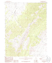
1986 Map of Boone Spring
USGS Topo · Published 1986About this map
The Pequop Mountains dominate this high-desert landscape in northeastern Nevada, rising sharply above the eastern margin of Independence Valley. This 1986 provisional survey captures the hydraulic importance of the range, where isolated water sources like Boone Spring and Lower Boone Spring provided critical stops for travelers and livestock in an otherwise arid environment. The map details a complex drainage network where Brush Creek and Cole Creek descend from the high peaks toward the valley floor, while to the south, the terrain opens into Coyote Basin. These seasonal watercourses and springs are the primary landmarks in a region defined by its topographic extremes and remote grazing lands, showing the land as it was documented before modern geographic shifts.
Find a feature on this map
8 named features on this map. Tap any name to fly to it.
Don’t see what you’re looking for? This feature index may not catch every label — zoom into the map to look around manually.
Map Details
Editions of this 1986 Boone Spring Map
This is the sole edition of this map. No revisions or reprints were ever made.
Other maps of this area

1953 · Spruce Mountain
USGS Topo · 1:62,500

1953 · Spruce Mountain 4
USGS Topo · 1:62,500

1955 · Elko
USGS Topo · 1:250,000

1958 · Elko
USGS Topo · 1:250,000

1962 · Elko
USGS Topo · 1:250,000

1965 · Elko
USGS Topo · 1:250,000

1982 · Mizpah
USGS Topo · 1:24,000
1982 · Mizpah Point
USGS Topo · 1:24,000
1984 · Palomino Ridge
USGS Topo · 1:24,000
1985 · Wendover
USGS Topo · 1:100,000