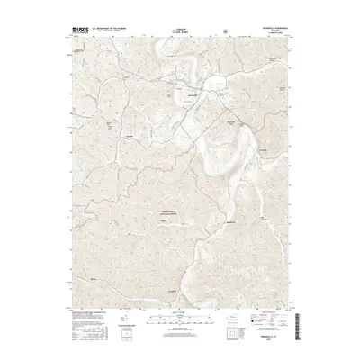
2016 Map of Booneville
USGS Topo · Published 2016About this map
Booneville serves as the central hub of this Owsley County landscape, situated near the unique geographic formation known as The Sag and the historic Boone Spring. The terrain is defined by a dense network of hollows and ridges, including Greenville Hollow and Halcomb Hollow, which dictate the winding paths of local thoroughfares like Veneable School Rd and Charley Turner Rd. Much of the southern portion of the quadrangle is integrated into the Daniel Boone National Forest, where the topography rises toward landmarks such as High Rock Mtn and Turkey Knob. Smaller settlements like Levi, Scoville, and Conkling are connected by a web of mountain roads, while the presence of Rowland Gay Cemetery Rd and family-named features like Boones Rock and Cawood Bend provide specific points of interest for those tracing local lineages and historical land use in this part of eastern Kentucky.
Find a feature on this map
52 named features on this map. Tap any name to fly to it.
Don’t see what you’re looking for? This feature index may not catch every label — zoom into the map to look around manually.
Map Details
Editions of this 2016 Booneville Map
This is the sole edition of this map. No revisions or reprints were ever made.
Other maps of this area

1891 · Manchester
USGS Topo · 1:125,000

1892 · Beattyville
USGS Topo · 1:125,000

1952 · Tallega
USGS Topo · 1:24,000

1952 · Beattyville
USGS Topo · 1:24,000

1952 · Heidelberg
USGS Topo · 1:24,000

1953 · Oneida
USGS Topo · 1:24,000

1953 · Cowcreek
USGS Topo · 1:24,000

1953 · Mistletoe
USGS Topo · 1:24,000

1953 · Booneville
USGS Topo · 1:24,000

1953 · Sturgeon
USGS Topo · 1:24,000