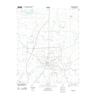
2012 Map of Booneville
USGS Topo · Published 2012About this map
Booneville serves as the central hub of this Prentiss County landscape, where the urban grid of the town center meets the surrounding agricultural and industrial outskirts. The drainage of the Tuscumbia River and Kings Creek shapes the local topography, while the man-made Booneville Lake provides a distinct water feature south of the primary settlement. The map documents several peripheral communities, including Sunflower, Gaston, and Bynum, alongside the modern residential development of Dogwood Ests. For genealogists and local historians, this survey is particularly valuable for its recording of numerous rural burial grounds such as Gaston Cemetery, Carolina Cemetery, and the Booneville Cemetery. The layout of the region is defined by a dense network of county roads that connect these smaller settlements and family-named landmarks across the northern Mississippi terrain.
Find a feature on this map
173 named features on this map. Tap any name to fly to it.
Don’t see what you’re looking for? This feature index may not catch every label — zoom into the map to look around manually.
Map Details
Editions of this 2012 Booneville Map
This is the sole edition of this map. No revisions or reprints were ever made.
Other maps of this area

1921 · Booneville
USGS Topo · 1:48,000

1922 · Booneville
USGS Topo · 1:62,500

1935 · Glens
USGS Topo · 1:24,000

1950 · Corinth
USGS Topo · 1:62,500

1950 · Glens
USGS Topo · 1:24,000

1950 · Altitude
USGS Topo · 1:24,000

1956 · Tupelo
USGS Topo · 1:250,000

1958 · Tupelo
USGS Topo · 1:250,000
1965 · Marietta
USGS Topo · 1:24,000

1972 · Jumpertown
USGS Topo · 1:24,000