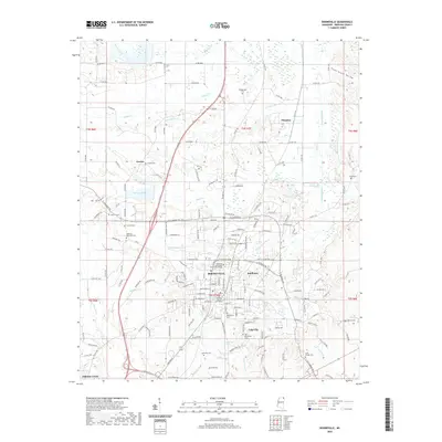
2020 Map of Booneville
USGS Topo · Published 2020About this map
Booneville serves as the focal point of this Prentiss County survey, where the Prentiss County Courthouse and Northeast Mississippi Community College anchor the downtown and educational district. The landscape is defined by the headwaters of several drainages, including the Tuscumbia River, Hornlucka Cr, and Tarlechia Cr, which carve through the terrain surrounding the city. Smaller outlying communities like Thrasher and Gaston reflect the rural settlement patterns typical of northeast Mississippi, while the presence of Booneville Lake provides a central water feature just south of the main township.
Find a feature on this map
165 named features on this map. Tap any name to fly to it.
Don’t see what you’re looking for? This feature index may not catch every label — zoom into the map to look around manually.
Map Details
Editions of this 2020 Booneville Map
This is the sole edition of this map. No revisions or reprints were ever made.
Other maps of this area

1921 · Booneville
USGS Topo · 1:48,000

1922 · Booneville
USGS Topo · 1:62,500

1935 · Glens
USGS Topo · 1:24,000

1950 · Corinth
USGS Topo · 1:62,500

1950 · Glens
USGS Topo · 1:24,000

1950 · Altitude
USGS Topo · 1:24,000

1956 · Tupelo
USGS Topo · 1:250,000

1958 · Tupelo
USGS Topo · 1:250,000
1965 · Marietta
USGS Topo · 1:24,000

1972 · Jumpertown
USGS Topo · 1:24,000