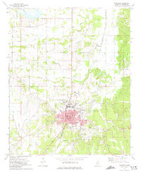
1973 Map of Booneville
USGS Topo · Published 1975About this map
Booneville serves as the focal point of this Prentiss County survey, showing the city's mid-century footprint centered on the Courthouse and City Hall. The municipal landscape is anchored by educational and healthcare institutions, including Northeast Mississippi Jr College, the Hospital, and several schools like Anderson High Sch. The Illinois Central Gulf railroad cuts through the heart of the region, facilitating a connection between the town center and outlying communities such as Thrasher and Gaston. The surrounding terrain is a network of small watercourses including Hornolucka Creek and the Tuscumbia River. Genealogists will find a wealth of data in the many rural religious sites and burial grounds, from the Oaklawn Memorial Park to smaller family-named landmarks like Stutts Chapel and Oak Hill Ch.
Find a feature on this map
48 named features on this map. Tap any name to fly to it.
Don’t see what you’re looking for? This feature index may not catch every label — zoom into the map to look around manually.
Map Details
Editions of this 1973 Booneville Map
This is the sole edition of this map. No revisions or reprints were ever made.
Other maps of this area

1921 · Booneville
USGS Topo · 1:48,000

1922 · Booneville
USGS Topo · 1:62,500

1935 · Glens
USGS Topo · 1:24,000

1950 · Corinth
USGS Topo · 1:62,500

1950 · Glens
USGS Topo · 1:24,000

1950 · Altitude
USGS Topo · 1:24,000

1956 · Tupelo
USGS Topo · 1:250,000

1958 · Tupelo
USGS Topo · 1:250,000
1965 · Marietta
USGS Topo · 1:24,000

1972 · Jumpertown
USGS Topo · 1:24,000