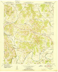
1951 Map of Boonshill
USGS Topo · Published 1951About this map
Boonshill and its neighboring rural settlements are documented here during the early post-war era, situated among the complex drainage systems of the Elk River. The map reveals a deeply established social landscape through its density of rural institutions, such as Beech Grove Church, Browns Temple Church, and schoolhouses like Mary Chapel School. The terrain is characterized by numerous hollows, including Reed Hollow and Sawyer Hollow, which dictate the winding paths of local roads and the placement of family farms. The presence of Old Fishing Ford Road and the Union Camp Ground Branch points to the historical importance of river access and community gathering spaces in Lincoln County. Several small hamlets such as East Cyruston and Pearl City are visible alongside the river's loops, like Hovis Bend and Pitts Bend, showing how the water's course shaped agricultural boundaries and transportation routes.
Find a feature on this map
58 named features on this map. Tap any name to fly to it.
Don’t see what you’re looking for? This feature index may not catch every label — zoom into the map to look around manually.
Map Details
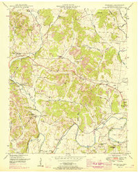
Editions of this 1951 Boonshill Map
2 editions found
Other maps of this area

1936 · Cornersville
USGS Topo · 1:24,000

1936 · Taft
USGS Topo · 1:24,000

1936 · Belleville
USGS Topo · 1:24,000

1936 · Boonshill
USGS Topo · 1:24,000

1936 · Petersburg
USGS Topo · 1:24,000

1936 · Lincoln
USGS Topo · 1:24,000

1936 · Frankewing
USGS Topo · 1:24,000

1936 · Fayetteville
USGS Topo · 1:24,000

1936 · Dellrose
USGS Topo · 1:24,000

1944 · Shelbyville
USGS Topo · 1:100,000