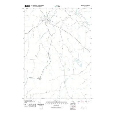
2010 Map of Boonville
USGS Topo · Published 2010About this map
Boonville serves as the central hub for this upstate New York landscape, situated where the Black River and Moose Creek converge near the northeastern corner of the map. The village layout is defined by its historic water-management infrastructure, notably the Boonville Reservoir and the Canal Towpath which follows the waterway north past Hawkinsville. To the south, the terrain descends along the Lansing Kill through Hurlbutville, where the dramatic drop of Pixley Falls highlights the region's steep geography. This 2010 survey illustrates a mix of traditional agriculture and recreational spaces, including the Maple Lawn Golf Course and several prominent heights like Potato Hill and Jackson Hill. Researchers can find evidence of early settlement patterns at the Hayes Cemetery and Egypt Cemetery, while more modern infrastructure is noted at the Boonville Landing Field.
Find a feature on this map
63 named features on this map. Tap any name to fly to it.
Don’t see what you’re looking for? This feature index may not catch every label — zoom into the map to look around manually.
Map Details
Editions of this 2010 Boonville Map
This is the sole edition of this map. No revisions or reprints were ever made.
Other maps of this area

1897 · Remsen
USGS Topo · 1:62,500

1900 · Remsen
USGS Topo · 1:62,500

1904 · Boonville
USGS Topo · 1:62,500

1905 · Port Leyden
USGS Topo · 1:62,500

1907 · Port Leyden
USGS Topo · 1:62,500

1912 · Mc Keever
USGS Topo · 1:62,500

1940 · Port Leyden
USGS Topo · 1:62,500

1945 · Boonville
USGS Topo · 1:24,000

1945 · Forestport
USGS Topo · 1:24,000
1946 · West Leyden
USGS Topo · 1:31,680