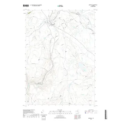
2019 Map of Boonville
USGS Topo · Published 2019About this map
The village of Boonville serves as the focal point of this region, situated where the Black River Canal and its associated Canal Towpath shaped the early industrial and transport character of the Oneida-Lewis county line. This survey details the transition from the structured street grid of the village, featuring names like E Schuyler St and Academy St, to the high-elevation terrain of the Tug Hill region. Notable for genealogists, the map identifies several burial grounds including Boonville Cem, Hayes Cem, and the remote North Steuben Cem to the south.
Find a feature on this map
86 named features on this map. Tap any name to fly to it.
Don’t see what you’re looking for? This feature index may not catch every label — zoom into the map to look around manually.
Map Details
Editions of this 2019 Boonville Map
This is the sole edition of this map. No revisions or reprints were ever made.
Other maps of this area

1897 · Remsen
USGS Topo · 1:62,500

1900 · Remsen
USGS Topo · 1:62,500

1904 · Boonville
USGS Topo · 1:62,500

1905 · Port Leyden
USGS Topo · 1:62,500

1907 · Port Leyden
USGS Topo · 1:62,500

1912 · Mc Keever
USGS Topo · 1:62,500

1940 · Port Leyden
USGS Topo · 1:62,500

1945 · Boonville
USGS Topo · 1:24,000

1945 · Forestport
USGS Topo · 1:24,000
1946 · West Leyden
USGS Topo · 1:31,680