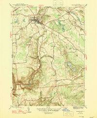
1947 Map of Boonville
USGS Topo · Published 1947About this map
Boonville serves as the primary hub of this 1940s landscape, positioned near the junction of the Black River Canal and several significant waterways. The map illustrates a transitional era for the region's transport, showing the canal's path alongside the Black River and Lansing Kill, south toward the dramatic drop of Boonville Gorge State Park and Pixley Falls. The surrounding rural landscape is densely marked with evidence of early 20th-century community life, including a series of numbered district schools like School No 11 and School No 5, and family-named locations such as Hayes Cem and Sperry Hill. To the south, North Steuben and its namesake North Steuben Ch sit atop the high ground between Cincinnati Creek and the deep gorge, while the Boonville Landing Field represents the emerging aviation infrastructure of the post-war period.
Find a feature on this map
43 named features on this map. Tap any name to fly to it.
Don’t see what you’re looking for? This feature index may not catch every label — zoom into the map to look around manually.
Map Details
Editions of this 1947 Boonville Map
This is the sole edition of this map. No revisions or reprints were ever made.
Other maps of this area

1897 · Remsen
USGS Topo · 1:62,500

1900 · Remsen
USGS Topo · 1:62,500

1904 · Boonville
USGS Topo · 1:62,500

1905 · Port Leyden
USGS Topo · 1:62,500

1907 · Port Leyden
USGS Topo · 1:62,500

1912 · Mc Keever
USGS Topo · 1:62,500

1940 · Port Leyden
USGS Topo · 1:62,500

1945 · Boonville
USGS Topo · 1:24,000

1945 · Forestport
USGS Topo · 1:24,000
1946 · West Leyden
USGS Topo · 1:31,680