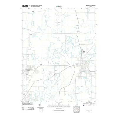
2010 Map of Boonville
USGS Topo · Published 2010About this map
Boonville serves as the primary hub of this Warrick County landscape, where the town's street grid meets the sprawling municipal reservoirs of City Lake Number One and City Lake Number Two. The surrounding terrain is defined by a dense network of country roads and the legacy of local industry, specifically marked by the Houston Mine and Shaw Mine located north of the city. These sites, along with the Boonville Airport, point to the region's diverse economic development alongside traditional agriculture.
Find a feature on this map
68 named features on this map. Tap any name to fly to it.
Don’t see what you’re looking for? This feature index may not catch every label — zoom into the map to look around manually.
Map Details
Editions of this 2010 Boonville Map
This is the sole edition of this map. No revisions or reprints were ever made.
Other maps of this area

1900 · De Gonia Springs
USGS Topo · 1:62,500

1901 · Owensboro
USGS Topo · 1:62,500

1902 · Ditney
USGS Topo · 1:125,000

1902 · Degonia Springs
USGS Topo · 1:62,500

1902 · Boonville
USGS Topo · 1:62,500

1905 · Newburg
USGS Topo · 1:62,500

1951 · Yankeetown
USGS Topo · 1:24,000

1952 · Newburgh
USGS Topo · 1:24,000

1954 · Evansville
USGS Topo · 1:250,000
1954 · Richland
USGS Topo · 1:24,000