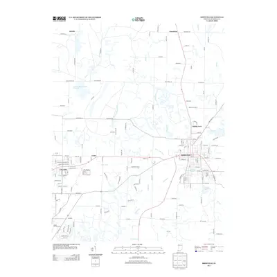
2013 Map of Boonville
USGS Topo · Published 2013About this map
The city of Boonville serves as a central hub for this portion of Warrick County, surrounded by smaller communities like Chandler, Greenbrier, and Rolling Acres. The landscape is defined by an extensive network of human-engineered drainage, including Kelly Ditch, Carter Traylor Ditch, and Pursley Ditch, which manage the flow through the Cypress Creek basin. These waterworks, alongside the Washing Recirculating Reservoir, point to the region's historical industrial needs, specifically its legacy of coal mining, hinted at by local routes such as Square Deal Mine Rd. To the west, the map details the residential expansion near Rolling Hills Golf Course, while the city center features local landmarks like City Lake Number One and City Lake Number Two, providing essential public space and resources for the community. The inclusion of Boonville Airport and the surrounding road grid reflects the steady development of this southwestern Indiana landscape in the early 21st century.
Find a feature on this map
156 named features on this map. Tap any name to fly to it.
Don’t see what you’re looking for? This feature index may not catch every label — zoom into the map to look around manually.
Map Details
Editions of this 2013 Boonville Map
This is the sole edition of this map. No revisions or reprints were ever made.
Other maps of this area

1900 · De Gonia Springs
USGS Topo · 1:62,500

1901 · Owensboro
USGS Topo · 1:62,500

1902 · Ditney
USGS Topo · 1:125,000

1902 · Degonia Springs
USGS Topo · 1:62,500

1902 · Boonville
USGS Topo · 1:62,500

1905 · Newburg
USGS Topo · 1:62,500

1951 · Yankeetown
USGS Topo · 1:24,000

1952 · Newburgh
USGS Topo · 1:24,000

1954 · Evansville
USGS Topo · 1:250,000
1954 · Richland
USGS Topo · 1:24,000