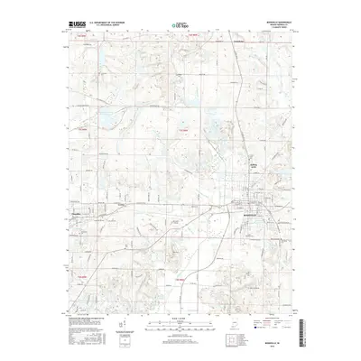
2016 Map of Boonville
USGS Topo · Published 2016About this map
Boonville, the seat of Warrick County, serves as the primary hub of this southern Indiana landscape, exhibiting a dense street grid that transitions into the outlying residential areas of Rolling Acres and the neighboring town of Chandler. The rural surroundings are characterized by an extensive network of drainage ditches, including Kelly Ditch and Carter Traylor Ditch, which manage the low-lying terrain north of the Boonville Airport. Local history and genealogy are well-represented by numerous family and community burial grounds such as Maple Grove Cem, Ellis Cem, and Crossroad Cem. To the north, the Washing Recirculating Reservoir and the Otter Creek drainage system highlight the ongoing management of water resources in an area historically tied to both agriculture and the regional mining industry.
Find a feature on this map
86 named features on this map. Tap any name to fly to it.
Don’t see what you’re looking for? This feature index may not catch every label — zoom into the map to look around manually.
Map Details
Editions of this 2016 Boonville Map
This is the sole edition of this map. No revisions or reprints were ever made.
Other maps of this area

1900 · De Gonia Springs
USGS Topo · 1:62,500

1901 · Owensboro
USGS Topo · 1:62,500

1902 · Ditney
USGS Topo · 1:125,000

1902 · Degonia Springs
USGS Topo · 1:62,500

1902 · Boonville
USGS Topo · 1:62,500

1905 · Newburg
USGS Topo · 1:62,500

1951 · Yankeetown
USGS Topo · 1:24,000

1952 · Newburgh
USGS Topo · 1:24,000

1954 · Evansville
USGS Topo · 1:250,000
1954 · Richland
USGS Topo · 1:24,000