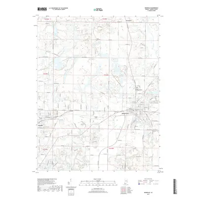
2019 Map of Boonville
USGS Topo · Published 2019About this map
Boonville serves as the primary hub of this Warrick County landscape, where the local street grid meets the Boonville Airport and City Lake Number One. The map captures a transition from the dense residential blocks of the city to the surrounding rural reaches, marked by several significant burial grounds such as Maple Grove Cem and Thornburg Cem. To the west, the smaller community of Chandler sits near the winding course of Stollberg Ditch, while the settlement of Greenbrier anchors the northern portion of the quadrangle. A network of family-named roads and country routes, including Millersburg Rd and Crowville Rd, connects scattered farmsteads and rural crossroads like Center. The presence of numerous small cemeteries like Ellis Cem and Perigo Cem provides specific points of interest for genealogists tracing local families across these townships.
Find a feature on this map
145 named features on this map. Tap any name to fly to it.
Don’t see what you’re looking for? This feature index may not catch every label — zoom into the map to look around manually.
Map Details
Editions of this 2019 Boonville Map
This is the sole edition of this map. No revisions or reprints were ever made.
Other maps of this area

1900 · De Gonia Springs
USGS Topo · 1:62,500

1901 · Owensboro
USGS Topo · 1:62,500

1902 · Ditney
USGS Topo · 1:125,000

1902 · Degonia Springs
USGS Topo · 1:62,500

1902 · Boonville
USGS Topo · 1:62,500

1905 · Newburg
USGS Topo · 1:62,500

1951 · Yankeetown
USGS Topo · 1:24,000

1952 · Newburgh
USGS Topo · 1:24,000

1954 · Evansville
USGS Topo · 1:250,000
1954 · Richland
USGS Topo · 1:24,000