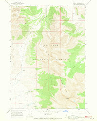
1967 Map of Borah Peak
USGS Topo · Published 1971About this map
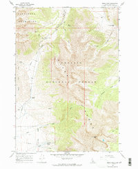
Borah Peak dominates this high-altitude landscape within the Challis National Forest, reaching an elevation of 12,662 feet. The 1967 survey documents the dramatic topography of the Pahsimeroi Mountains, where high mountain passes like Doublespring Pass and Horseheaven Pass provided critical transit points across the range. Water sources are meticulously noted in this arid environment, ranging from Mule Spring and Freighter Spring to a small Dam and Aqueduct located near Birch Springs and Cedar Creek. The drainage patterns are clearly defined by Willow Creek and Mahogany Creek, illustrating the complex watershed of the Lost River Range. This map serves as an essential record of the area's physical geography before the expansion of modern recreational infrastructure, preserving the names of remote canyons like Cayuse Canyon and local water management features used during the mid-20th century.
Find a feature on this map
20 named features on this map. Tap any name to fly to it.
Don’t see what you’re looking for? This feature index may not catch every label — zoom into the map to look around manually.
Map Details
Editions of this 1967 Borah Peak Map
2 editions found
Other maps of this area

1935 · Borah Peak
USGS Topo · 1:125,000

1938 · Borah Peak
USGS Topo · 1:125,000

1955 · Dubois
USGS Topo · 1:250,000

1956 · Donkey Hills
USGS Topo · 1:62,500

1956 · Doublespring
USGS Topo · 1:62,500

1958 · Dubois
USGS Topo · 1:250,000
1962 · Leatherman Peak
USGS Topo · 1:24,000
1967 · Burnt Creek
USGS Topo · 1:24,000
1967 · Elkhorn Creek
USGS Topo · 1:24,000
1967 · Borah Peak
USGS Topo · 1:24,000