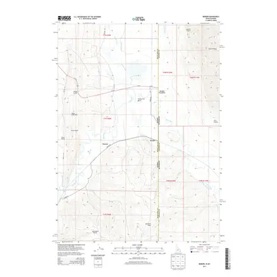
2013 Map of Border
USGS Topo · Published 2013About this map
Thomas Fork Valley anchors this high-desert landscape where the Bear River meanders across the state line between Idaho and Wyoming. This 2013 survey illustrates the complex irrigation network vital to the region, featuring the Raymond Canal, Cook Canal, and Nuffer Canal which divert water to the surrounding basins. The small settlements of Border Junction and Border sit at the intersection of Us-30 E and Border Rd, serving as crossroads for those traveling through the Sublette Range or towards the Preuss Range to the west. Local topography is defined by significant landmarks such as Border Summit, Boundary Ridge, and the winding Swine Bend Hollow. The map also captures several family-named water features like Etcheverry Ditch and Francis Ditch, reflecting the long-standing agricultural history of these borderland communities.
Find a feature on this map
43 named features on this map. Tap any name to fly to it.
Don’t see what you’re looking for? This feature index may not catch every label — zoom into the map to look around manually.
Map Details
Editions of this 2013 Border Map
This is the sole edition of this map. No revisions or reprints were ever made.
Other maps of this area

1909 · Montpelier
USGS Topo · 1:125,000

1911 · Montpelier
USGS Topo · 1:125,000

1936 · Cokeville
USGS Topo · 1:96,000

1942 · Cokeville
USGS Topo · 1:125,000

1955 · Preston
USGS Topo · 1:250,000

1958 · Preston
USGS Topo · 1:250,000

1962 · Preston
USGS Topo · 1:250,000

1967 · Huff Lake
USGS Topo · 1:24,000
1967 · Marse
USGS Topo · 1:24,000
1967 · Cokeville
USGS Topo · 1:24,000