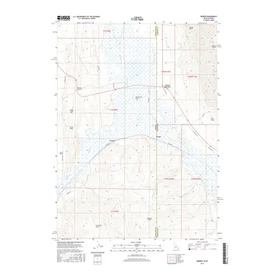
2017 Map of Border
USGS Topo · Published 2017About this map
Border Junction marks the convergence of transit and state lines in this high-elevation corridor where Idaho and Wyoming meet. The landscape is defined by the hydrologic engineering of the Thomas Fork Valley, where the Thomas Fork and its complex network of irrigation features like the Raymond Canal and Etcheverry Ditch support the ranching economy of the high plains. The Bear River meanders through the southern half of the sheet, flanked by the Preuss Range and the Sublette Range, which create natural barriers only overcome by passages like Border Summit. This map illustrates the vital role of water management in the intermountain West, visible in the numerous diversions such as Miller Ditch, Nuffer Canal, and Rocky Point Ditch that lace the valley floors between Chausse and the Rio Oso Ranch.
Find a feature on this map
46 named features on this map. Tap any name to fly to it.
Don’t see what you’re looking for? This feature index may not catch every label — zoom into the map to look around manually.
Map Details
Editions of this 2017 Border Map
This is the sole edition of this map. No revisions or reprints were ever made.
Other maps of this area

1909 · Montpelier
USGS Topo · 1:125,000

1911 · Montpelier
USGS Topo · 1:125,000

1936 · Cokeville
USGS Topo · 1:96,000

1942 · Cokeville
USGS Topo · 1:125,000

1955 · Preston
USGS Topo · 1:250,000

1958 · Preston
USGS Topo · 1:250,000

1962 · Preston
USGS Topo · 1:250,000

1967 · Huff Lake
USGS Topo · 1:24,000
1967 · Marse
USGS Topo · 1:24,000
1967 · Cokeville
USGS Topo · 1:24,000