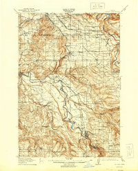
1914 Map of Boring
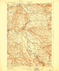
USGS Topo · Published 1944About this map
The Clackamas River and Sandy River define the industrial and transit corridors of this region during the early twentieth century. This survey, conducted by R.B. Marshall and his team, illustrates a landscape transitioning from pioneer homesteads to established townships linked by the Portland Railway Light & Power Company. The Cazadero Line and Oregon Water Power & Railway Company tracks provide the essential infrastructure for movement between Gresham and Estacada.
Find a feature on this map
72 named features on this map. Tap any name to fly to it.
Don’t see what you’re looking for? This feature index may not catch every label — zoom into the map to look around manually.
Map Details
Editions of this 1914 Boring Map
3 editions found
Other maps of this area

1897 · Portland
USGS Topo · 1:62,500

1905 · Portland
USGS Topo · 1:62,500

1911 · Boring
USGS Topo · 1:48,000

1914 · Boring
USGS Topo · 1:62,500

1914 · Oregon City
USGS Topo · 1:62,500

1916 · Estacada
USGS Topo · 1:125,000

1918 · Troutdale
USGS Topo · 1:62,500

1934 · Troutdale
USGS Topo · 1:48,000

1939 · Molalla
USGS Topo · 1:62,500

1939 · Oregon City
USGS Topo · 1:62,500