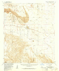
1960 Map of Borrego Mountain
USGS Topo · Published 1961About this map
The Borrego Badlands dominate this arid landscape, showing a complex network of ephemeral drainage systems like San Felipe Wash and Palo Verde Wash. In the early 1960s, this portion of the Anza-Borrego Desert State Park centered on the small outpost of Ocotillo Wells, which served as a focal point for desert travel near the Los Puertocitos Historical Marker. The map reveals a land defined by water scarcity, noting several dry sites such as Wolfe Well (Dry) and the Little Borrego (Site).
Find a feature on this map
54 named features on this map. Tap any name to fly to it.
Don’t see what you’re looking for? This feature index may not catch every label — zoom into the map to look around manually.
Map Details
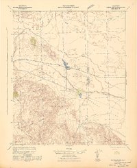
Editions of this 1960 Borrego Mountain Map
2 editions found

Other maps of this area

1904 · Indio
USGS Topo · 1:125,000

1915 · El Centro
USGS Topo · 1:125,000

1931 · Vallecito
USGS Topo · 1:125,000

1931 · Carrizo
USGS Topo · 1:125,000

1939 · Borrego
USGS Topo · 1:62,500

1940 · Kane Spring
USGS Topo · 1:62,500

1940 · Plaster City
USGS Topo · 1:62,500

1940 · Durmid
USGS Topo · 1:62,500

1941 · Clark Lake
USGS Topo · 1:62,500
1942 · Barrel Spring
USGS Topo · 1:62,500