
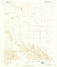
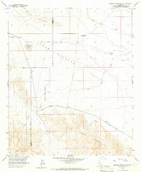
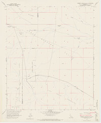
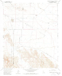
1958 Map of Borrego Mountain SE
USGS Topo · Published 1982About this map
Ocotillo Badlands and the arid expanse of the Lower Borrego Valley dominate this mid-century survey of the California desert. The landscape is defined by its harsh geography, where reliable water was a primary concern, as evidenced by Baileys Well (Dry) and the County Well (Dry) Spring. This era captures the footprint of the Anza-Borrego Desert State Park as it integrates with the surrounding mountains, including the Vallecito Mts and Fish Creek Mountains. Significant human activity is noted by the presence of a Mining Railroad and several quarries, indicating industrial efforts to extract resources from the terrain near Split Mountain. A notable historical site includes Little Borego (Site), located along the Old Kane Spring Road, providing a clear look at the early transportation network and sparse settlement patterns before further modernization of the Imperial County region.
Find a feature on this map
19 named features on this map. Tap any name to fly to it.
Don’t see what you’re looking for? This feature index may not catch every label — zoom into the map to look around manually.
Map Details
Editions of this 1958 Borrego Mountain SE Map
5 editions found
Historical Maps of Little Borrego Through Time
419 maps found

1940 Alamorio
Imperial County, CA

1940 Coyote Wells
Imperial County, CA

1940 Durmid
Imperial County, CA

1940 Frink
Imperial County, CA

1940 Iris
Imperial County, CA

1940 Iris Pass
Imperial County, CA

1940 Kane Spring
Imperial County, CA

1940 Plaster City
Imperial County, CA

1943 Coyote Wells
Imperial County, CA

1944 Durmid
Imperial County, CA

1944 Frink
Imperial County, CA

1944 Kane Spring
Imperial County, CA

1944 Plaster City
Imperial County, CA

1945 Alamorio
Imperial County, CA

1945 Iris
Imperial County, CA

1945 Iris Pass
Imperial County, CA

1945 Picacho Peak
Imperial County, CA

1951 Picacho Peak
Imperial County, CA

1952 Araz
Imperial County, CA

1952 Bard
Imperial County, CA

1953 Acolita
Imperial County, CA

1953 Acolita
Imperial County, CA

1953 Cactus
Imperial County, CA

1953 Chuckwalla Spring
Imperial County, CA

1953 Grays Well
Imperial County, CA

1953 Grays Well NE
Imperial County, CA

1953 Ogilby
Imperial County, CA

1953 Palo Verde Mountains
Imperial County, CA

1953 Quartz Peak
Imperial County, CA

1954 Glamis NW
Imperial County, CA

1954 Glamis SE
Imperial County, CA

1954 Glamis SW
Imperial County, CA

1954 Little Picacho Peak
Imperial County, CA

1954 Midway Well
Imperial County, CA

1954 Midway Well
Imperial County, CA

1954 Midway Well NW
Imperial County, CA

1954 Picacho NW
Imperial County, CA

1954 Picacho SW
Imperial County, CA

1954 Salton Sea
Imperial County, CA

1955 Glamis
Imperial County, CA

1955 Glamis
Imperial County, CA

1955 Salton Sea
Imperial County, CA

1955 Tortuga
Imperial County, CA

1956 Alamorio
Imperial County, CA

1956 Amos
Imperial County, CA

1956 Calipatria SW
Imperial County, CA

1956 Durmid SE
Imperial County, CA

1956 Frink
Imperial County, CA

1956 Frink
Imperial County, CA

1956 Harpers Well
Imperial County, CA

1956 Holtville West
Imperial County, CA

1956 Iris
Imperial County, CA

1956 Iris Wash
Imperial County, CA

1956 Kane Spring
Imperial County, CA

1956 Kane Spring NE
Imperial County, CA

1956 Kane Spring NW
Imperial County, CA

1956 Obsidian Butte
Imperial County, CA

1956 Plaster City NW
Imperial County, CA

1956 Seventeen Palms
Imperial County, CA

1956 Superstition Mtn
Imperial County, CA

1956 Truckhaven
Imperial County, CA

1956 Wiest
Imperial County, CA

1956 Wister
Imperial County, CA

1957 Bonds Corner
Imperial County, CA

1957 Brawley NW
Imperial County, CA

1957 Carrizo Mtn
Imperial County, CA

1957 Carrizo Mtn NE
Imperial County, CA

1957 Coyote Wells
Imperial County, CA

1957 Coyote Wells
Imperial County, CA

1957 Durmid
Imperial County, CA

1957 Holtville East
Imperial County, CA

1957 Holtville NE
Imperial County, CA

1957 Mount Signal
Imperial County, CA

1957 Painted Gorge
Imperial County, CA

1957 Plaster City
Imperial County, CA

1957 Plaster City
Imperial County, CA

1957 Yuha Basin
Imperial County, CA
1958 Borrego Mountain SE
Imperial County, CA

1959 Harpers Well
Imperial County, CA

1959 In-ko-pah Gorge
Imperial County, CA

1959 Salton Sea
Imperial County, CA

1959 Shell Reef
Imperial County, CA

1963 Cactus
Imperial County, CA

1963 Iris Pass
Imperial County, CA

1963 Ogilby
Imperial County, CA

1963 Salton Sea
Imperial County, CA

1964 Araz
Imperial County, CA

1964 Grays Well
Imperial County, CA

1964 Grays Well NE
Imperial County, CA

1964 Picacho
Imperial County, CA

1965 Bard
Imperial County, CA

1965 Little Picacho Peak
Imperial County, CA

1965 Picacho NW
Imperial County, CA

1965 Picacho Peak
Imperial County, CA

1965 Picacho SW
Imperial County, CA

1965 Salton Sea
Imperial County, CA

1985 Salton Sea
Imperial County, CA

1986 Lion Head Mountain
Imperial County, CA

1988 Blue Mountain
Imperial County, CA

1988 Buzzards Peak
Imperial County, CA

1988 Clyde
Imperial County, CA

1988 East of Acolita
Imperial County, CA

1988 Hedges
Imperial County, CA

1988 Little Mule Mountains
Imperial County, CA

1988 Mammoth Wash
Imperial County, CA

1988 Mt. Barrow
Imperial County, CA

1988 Ninemile Wash
Imperial County, CA

1988 Ogilby
Imperial County, CA

1988 Palo Verde Peak
Imperial County, CA

1988 Pegleg Well
Imperial County, CA

1988 Quartz Peak
Imperial County, CA

1988 West of Palo Verde Peak
Imperial County, CA

1992 Acolita
Imperial County, CA

1992 Amos
Imperial County, CA

1992 Durmid SE
Imperial County, CA

1992 Frink
Imperial County, CA

1992 Harpers Well
Imperial County, CA

1992 Iris
Imperial County, CA

1992 Iris Wash
Imperial County, CA

1992 Kane Spring
Imperial County, CA

1992 Kane Spring NE
Imperial County, CA

1992 Kane Spring NW
Imperial County, CA

1992 Obsidian Butte
Imperial County, CA

1992 Tortuga
Imperial County, CA

1992 Truckhaven
Imperial County, CA

1992 Westmorland East
Imperial County, CA

1992 Westmorland West
Imperial County, CA

1992 Wiest
Imperial County, CA

1992 Wister
Imperial County, CA

1997 In-ko-pah Gorge
Imperial County, CA

1997 Ogilby
Imperial County, CA

1998 Acolita
Imperial County, CA

1998 Durmid SE
Imperial County, CA

1998 Frink
Imperial County, CA

1998 Harpers Well
Imperial County, CA

1998 Iris Wash
Imperial County, CA

1998 Kane Spring NW
Imperial County, CA

1998 Tortuga
Imperial County, CA

1998 Truckhaven
Imperial County, CA

2002 Acolita
Imperial County, CA

2002 Chuckwalla Spring
Imperial County, CA

2002 Durmid
Imperial County, CA

2002 Frink
Imperial County, CA

2002 Iris
Imperial County, CA

2002 Palo Verde Mountains
Imperial County, CA

2002 Quartz Peak
Imperial County, CA

2012 Acolita
Imperial County, CA

2012 Alamorio
Imperial County, CA

2012 Amos
Imperial County, CA

2012 Araz
Imperial County, CA

2012 Bard
Imperial County, CA

2012 Blue Mountain
Imperial County, CA

2012 Bonds Corner
Imperial County, CA

2012 Borrego Mountain SE
Imperial County, CA

2012 Brawley NW
Imperial County, CA

2012 Buzzards Peak
Imperial County, CA

2012 Cactus
Imperial County, CA

2012 Carrizo Mountain
Imperial County, CA

2012 Carrizo Mountain NE
Imperial County, CA

2012 Clyde
Imperial County, CA

2012 Coyote Wells
Imperial County, CA

2012 Durmid SE
Imperial County, CA

2012 East of Acolita
Imperial County, CA

2012 Frink
Imperial County, CA

2012 Glamis
Imperial County, CA

2012 Glamis NW
Imperial County, CA

2012 Glamis SE
Imperial County, CA

2012 Glamis SW
Imperial County, CA

2012 Grays Well
Imperial County, CA

2012 Grays Well NE
Imperial County, CA

2012 Harpers Well
Imperial County, CA

2012 Hedges
Imperial County, CA

2012 Holtville East
Imperial County, CA

2012 Holtville NE
Imperial County, CA

2012 Holtville West
Imperial County, CA

2012 In-Ko-Pah Gorge
Imperial County, CA

2012 In-Ko-Pah Gorge OE S
Imperial County, CA

2012 Iris
Imperial County, CA

2012 Iris Wash
Imperial County, CA

2012 Kane Spring
Imperial County, CA

2012 Kane Spring NE
Imperial County, CA

2012 Kane Spring NW
Imperial County, CA

2012 Lion Head Mountain
Imperial County, CA

2012 Little Mule Mountains
Imperial County, CA

2012 Little Picacho Peak
Imperial County, CA

2012 Mammoth Wash
Imperial County, CA

2012 Midway Well
Imperial County, CA

2012 Midway Well NW
Imperial County, CA

2012 Mount Barrow
Imperial County, CA

2012 Mount Signal
Imperial County, CA

2012 Ninemile Wash
Imperial County, CA

2012 Obsidian Butte
Imperial County, CA

2012 Ogilby
Imperial County, CA

2012 Painted Gorge
Imperial County, CA

2012 Palo Verde Peak
Imperial County, CA

2012 Pegleg Well
Imperial County, CA

2012 Picacho
Imperial County, CA

2012 Picacho NW
Imperial County, CA

2012 Picacho Peak
Imperial County, CA

2012 Picacho SW
Imperial County, CA

2012 Plaster City
Imperial County, CA

2012 Plaster City NW
Imperial County, CA

2012 Quartz Peak
Imperial County, CA

2012 Seventeen Palms
Imperial County, CA

2012 Shell Reef
Imperial County, CA

2012 Superstition Mountain
Imperial County, CA

2012 Tortuga
Imperial County, CA

2012 Truckhaven
Imperial County, CA

2012 Westmorland East
Imperial County, CA

2012 Westmorland West
Imperial County, CA

2012 West of Palo Verde Peak
Imperial County, CA

2012 Wiest
Imperial County, CA

2012 Wister
Imperial County, CA

2012 Yuha Basin
Imperial County, CA

2015 Acolita
Imperial County, CA

2015 Alamorio
Imperial County, CA

2015 Amos
Imperial County, CA

2015 Araz
Imperial County, CA

2015 Bard
Imperial County, CA

2015 Blue Mountain
Imperial County, CA

2015 Bonds Corner
Imperial County, CA

2015 Borrego Mountain SE
Imperial County, CA

2015 Brawley NW
Imperial County, CA

2015 Buzzards Peak
Imperial County, CA

2015 Cactus
Imperial County, CA

2015 Carrizo Mountain
Imperial County, CA

2015 Carrizo Mountain NE
Imperial County, CA

2015 Clyde
Imperial County, CA

2015 Coyote Wells
Imperial County, CA

2015 Durmid SE
Imperial County, CA

2015 East of Acolita
Imperial County, CA

2015 Frink
Imperial County, CA

2015 Glamis
Imperial County, CA

2015 Glamis NW
Imperial County, CA

2015 Glamis SE
Imperial County, CA

2015 Glamis SW
Imperial County, CA

2015 Grays Well
Imperial County, CA

2015 Grays Well NE
Imperial County, CA

2015 Harpers Well
Imperial County, CA

2015 Hedges
Imperial County, CA

2015 Holtville East
Imperial County, CA

2015 Holtville NE
Imperial County, CA

2015 Holtville West
Imperial County, CA

2015 In-Ko-Pah Gorge
Imperial County, CA

2015 In-Ko-Pah Gorge OE S
Imperial County, CA

2015 Iris
Imperial County, CA

2015 Iris Wash
Imperial County, CA

2015 Kane Spring
Imperial County, CA

2015 Kane Spring NE
Imperial County, CA

2015 Kane Spring NW
Imperial County, CA

2015 Lion Head Mountain
Imperial County, CA

2015 Little Mule Mountains
Imperial County, CA

2015 Little Picacho Peak
Imperial County, CA

2015 Mammoth Wash
Imperial County, CA

2015 Midway Well
Imperial County, CA

2015 Midway Well NW
Imperial County, CA

2015 Mount Barrow
Imperial County, CA

2015 Mount Signal
Imperial County, CA

2015 Ninemile Wash
Imperial County, CA

2015 Obsidian Butte
Imperial County, CA

2015 Ogilby
Imperial County, CA

2015 Painted Gorge
Imperial County, CA

2015 Palo Verde Peak
Imperial County, CA

2015 Pegleg Well
Imperial County, CA

2015 Picacho
Imperial County, CA

2015 Picacho NW
Imperial County, CA

2015 Picacho Peak
Imperial County, CA

2015 Picacho SW
Imperial County, CA

2015 Plaster City
Imperial County, CA

2015 Plaster City NW
Imperial County, CA

2015 Quartz Peak
Imperial County, CA

2015 Seventeen Palms
Imperial County, CA

2015 Shell Reef
Imperial County, CA

2015 Superstition Mountain
Imperial County, CA

2015 Tortuga
Imperial County, CA

2015 Truckhaven
Imperial County, CA

2015 Westmorland East
Imperial County, CA

2015 Westmorland West
Imperial County, CA

2015 West of Palo Verde Peak
Imperial County, CA

2015 Wiest
Imperial County, CA

2015 Wister
Imperial County, CA

2015 Yuha Basin
Imperial County, CA

2018 Acolita
Imperial County, CA

2018 Alamorio
Imperial County, CA

2018 Amos
Imperial County, CA

2018 Araz
Imperial County, CA

2018 Bard
Imperial County, CA

2018 Blue Mountain
Imperial County, CA

2018 Bonds Corner
Imperial County, CA

2018 Borrego Mountain SE
Imperial County, CA

2018 Brawley NW
Imperial County, CA

2018 Buzzards Peak
Imperial County, CA

2018 Cactus
Imperial County, CA

2018 Carrizo Mountain
Imperial County, CA

2018 Carrizo Mountain NE
Imperial County, CA

2018 Clyde
Imperial County, CA

2018 Coyote Wells
Imperial County, CA

2018 Durmid SE
Imperial County, CA

2018 East of Acolita
Imperial County, CA

2018 Frink
Imperial County, CA

2018 Glamis
Imperial County, CA

2018 Glamis NW
Imperial County, CA

2018 Glamis SE
Imperial County, CA

2018 Glamis SW
Imperial County, CA

2018 Grays Well
Imperial County, CA

2018 Grays Well NE
Imperial County, CA

2018 Harpers Well
Imperial County, CA

2018 Hedges
Imperial County, CA

2018 Holtville East
Imperial County, CA

2018 Holtville NE
Imperial County, CA

2018 Holtville West
Imperial County, CA

2018 In-Ko-Pah Gorge
Imperial County, CA

2018 In-Ko-Pah Gorge OE S
Imperial County, CA

2018 Iris
Imperial County, CA

2018 Iris Wash
Imperial County, CA

2018 Kane Spring
Imperial County, CA

2018 Kane Spring NE
Imperial County, CA

2018 Kane Spring NW
Imperial County, CA

2018 Lion Head Mountain
Imperial County, CA

2018 Little Mule Mountains
Imperial County, CA

2018 Little Picacho Peak
Imperial County, CA

2018 Mammoth Wash
Imperial County, CA

2018 Midway Well
Imperial County, CA

2018 Midway Well NW
Imperial County, CA

2018 Mount Barrow
Imperial County, CA

2018 Mount Signal
Imperial County, CA

2018 Ninemile Wash
Imperial County, CA

2018 Obsidian Butte
Imperial County, CA

2018 Ogilby
Imperial County, CA

2018 Painted Gorge
Imperial County, CA

2018 Palo Verde Peak
Imperial County, CA

2018 Pegleg Well
Imperial County, CA

2018 Picacho
Imperial County, CA

2018 Picacho NW
Imperial County, CA

2018 Picacho Peak
Imperial County, CA

2018 Picacho SW
Imperial County, CA

2018 Plaster City
Imperial County, CA

2018 Plaster City NW
Imperial County, CA

2018 Quartz Peak
Imperial County, CA

2018 Seventeen Palms
Imperial County, CA

2018 Shell Reef
Imperial County, CA

2018 Superstition Mountain
Imperial County, CA

2018 Tortuga
Imperial County, CA

2018 Truckhaven
Imperial County, CA

2018 Westmorland East
Imperial County, CA

2018 Westmorland West
Imperial County, CA

2018 West of Palo Verde Peak
Imperial County, CA

2018 Wiest
Imperial County, CA

2018 Wister
Imperial County, CA

2018 Yuha Basin
Imperial County, CA

2021 Acolita
Imperial County, CA

2021 Alamorio
Imperial County, CA

2021 Amos
Imperial County, CA

2021 Araz
Imperial County, CA

2021 Bard
Imperial County, CA

2021 Blue Mountain
Imperial County, CA

2021 Bonds Corner
Imperial County, CA

2021 Borrego Mountain SE
Imperial County, CA

2021 Brawley NW
Imperial County, CA

2021 Buzzards Peak
Imperial County, CA

2021 Cactus
Imperial County, CA

2021 Carrizo Mountain
Imperial County, CA

2021 Carrizo Mountain NE
Imperial County, CA

2021 Clyde
Imperial County, CA

2021 Coyote Wells
Imperial County, CA

2021 Durmid SE
Imperial County, CA

2021 East of Acolita
Imperial County, CA

2021 Frink
Imperial County, CA

2021 Glamis
Imperial County, CA

2021 Glamis NW
Imperial County, CA

2021 Glamis SE
Imperial County, CA

2021 Glamis SW
Imperial County, CA

2021 Grays Well
Imperial County, CA

2021 Grays Well NE
Imperial County, CA

2021 Harpers Well
Imperial County, CA

2021 Hedges
Imperial County, CA

2021 Holtville East
Imperial County, CA

2021 Holtville NE
Imperial County, CA

2021 Holtville West
Imperial County, CA

2021 In-Ko-Pah Gorge
Imperial County, CA

2021 In-Ko-Pah Gorge OE S
Imperial County, CA

2021 Iris
Imperial County, CA

2021 Iris Wash
Imperial County, CA

2021 Kane Spring
Imperial County, CA

2021 Kane Spring NE
Imperial County, CA

2021 Kane Spring NW
Imperial County, CA

2021 Lion Head Mountain
Imperial County, CA

2021 Little Mule Mountains
Imperial County, CA

2021 Mammoth Wash
Imperial County, CA

2021 Midway Well
Imperial County, CA

2021 Midway Well NW
Imperial County, CA

2021 Mount Barrow
Imperial County, CA

2021 Mount Signal
Imperial County, CA

2021 Ninemile Wash
Imperial County, CA

2021 Obsidian Butte
Imperial County, CA

2021 Ogilby
Imperial County, CA

2021 Painted Gorge
Imperial County, CA

2021 Palo Verde Peak
Imperial County, CA

2021 Pegleg Well
Imperial County, CA

2021 Picacho
Imperial County, CA

2021 Picacho NW
Imperial County, CA

2021 Picacho Peak
Imperial County, CA

2021 Picacho SW
Imperial County, CA

2021 Plaster City
Imperial County, CA

2021 Plaster City NW
Imperial County, CA

2021 Quartz Peak
Imperial County, CA

2021 Seventeen Palms
Imperial County, CA

2021 Shell Reef
Imperial County, CA

2021 Superstition Mountain
Imperial County, CA

2021 Tortuga
Imperial County, CA

2021 Truckhaven
Imperial County, CA

2021 Westmorland East
Imperial County, CA

2021 Westmorland West
Imperial County, CA

2021 West of Palo Verde Peak
Imperial County, CA

2021 Wiest
Imperial County, CA

2021 Wister
Imperial County, CA

2021 Yuha Basin
Imperial County, CA

2022 Little Picacho Peak
Imperial County, CA

2023 Shell Reef
Imperial County, CA