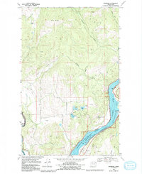
1969 Map of Bossburg
USGS Topo · Published 1992About this map
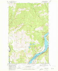
Bossburg sits along the eastern shore of Franklin D Roosevelt Lake in this late 1960s topographic study, illustrating a landscape shaped by both the Columbia River and the industrial extraction of its surrounding hills. The map highlights the intersection of recreation and industry, with the Lake Roosevelt National Recreation Area and North Gorge Campground bordering significant local mining operations. To the south of the settlement, the Northwest Marble Mine and the Young America Mine are prominent, while several smaller quarries and prospects are scattered throughout the terrain. Moving west across the water, the landscape rises into the prominent Kelly Hill, contrasting with the high northern peaks of Jumbo Mountain. The presence of small named settlements like Myers and Arnold along the roads provides important data for genealogists tracing local families in Stevens County. Natural water features, including Buhring Lake and the clustered Glasgo Lakes, punctuate the high-elevation drainages that feed the river system.
Find a feature on this map
30 named features on this map. Tap any name to fly to it.
Don’t see what you’re looking for? This feature index may not catch every label — zoom into the map to look around manually.
Map Details
Editions of this 1969 Bossburg Map
2 editions found
Other maps of this area

1929 · Colville
USGS Topo · 1:125,000

1933 · Colville
USGS Topo · 1:125,000

1936 · Marcus
USGS Topo · 1:96,000

1942 · Marcus
USGS Topo · 1:125,000

1948 · Kettle Falls
USGS Topo · 1:62,500

1948 · Orient
USGS Topo · 1:62,500

1951 · Orient
USGS Topo · 1:62,500

1951 · Kettle Falls
USGS Topo · 1:62,500

1952 · Echo Valley
USGS Topo · 1:24,000

1954 · Okanogan
USGS Topo · 1:250,000