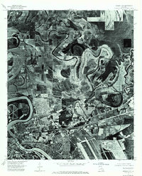
1975 Map of Bossier City
USGS Topo · Published 1976About this map
The Red River meanders in dramatic oxbows across this mid-1970s orthophotoquad, defining the physical boundary between Shreveport and Bossier City. This aerial-based survey provides a photographic perspective of the region's mid-century expansion, showing the dense residential patterns that pushed northward toward Brownlee. The southern portion of the image is dominated by the sprawling infrastructure of Barksdale Air Force Base, where runways and support facilities contrast with the winding river and agricultural fields to the north. Unlike traditional topographic maps, this imagery reveals the exact footprint of industrial sites, neighborhoods, and the complex riverbank stabilization efforts along the alluvial plain.
Find a feature on this map
5 named features on this map. Tap any name to fly to it.
Don’t see what you’re looking for? This feature index may not catch every label — zoom into the map to look around manually.
Map Details
Editions of this 1975 Bossier City Map
3 editions found
Other maps of this area

1932 · Bossier SE
USGS Topo · 1:31,680

1932 · Bossier NE
USGS Topo · 1:31,680

1932 · Bossier SW
USGS Topo · 1:31,680

1932 · Shreveport SE
USGS Topo · 1:31,680

1932 · Bossier NW
USGS Topo · 1:31,680

1932 · Shreveport NE
USGS Topo · 1:31,680

1938 · Arnsberg
USGS Topo · 1:31,680

1941 · Forbing
USGS Topo · 1:31,680

1945 · Greenwood
USGS Topo · 1:62,500

1948 · Mooringsport
USGS Topo · 1:62,500