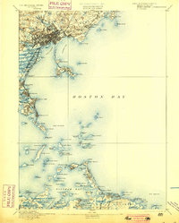
1892 Map of Boston Bay
USGS Topo · Published 1900About this map
Lynn serves as a dense urban anchor at the northern edge of this late nineteenth-century coastal study, where a complex network of rail lines including the Saugus Branch RR and the Eastern Division of Boston and Maine Railroad converge. The maritime landscape is defined by its defensive and navigational infrastructure, from the historic Fort Warren on George's Island to the vital beacons of Boston Light and Minot Ledge Light.
Find a feature on this map
137 named features on this map. Tap any name to fly to it.
Don’t see what you’re looking for? This feature index may not catch every label — zoom into the map to look around manually.
Map Details
Editions of this 1892 Boston Bay Map
4 editions found

Other maps of this area

1885 · Abington
USGS Topo · 1:62,500

1885 · Duxbury
USGS Topo · 1:62,500

1886 · Gloucester
USGS Topo · 1:62,500

1886 · Lawrence
USGS Topo · 1:62,500

1886 · Dedham
USGS Topo · 1:62,500

1888 · Duxbury
USGS Topo · 1:62,500

1888 · Gloucester
USGS Topo · 1:62,500

1888 · Lawrence
USGS Topo · 1:62,500

1888 · Salem
USGS Topo · 1:62,500

1888 · Abington
USGS Topo · 1:62,500