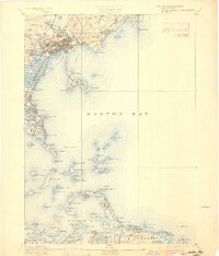
1892 Map of Boston Bay
USGS Topo · Published 1901About this map
Lynn Harbor and the intricate coastal geometry of Massachusetts Bay appear here in great detail, reflecting the region's late-19th-century maritime and rail-based development. The map meticulously documents the transition from urban centers like Lynn and Quincy to the resort-heavy shorelines of Swampscott and Hull. A dense network of railways, including the Boston Revere Beach & Lynn R.R. and the Nantasket Beach Railroad, follows the coast, indicating the era's reliance on rail for both industry and early tourism.
Find a feature on this map
138 named features on this map. Tap any name to fly to it.
Don’t see what you’re looking for? This feature index may not catch every label — zoom into the map to look around manually.
Map Details
Editions of this 1892 Boston Bay Map
4 editions found

Other maps of this area

1885 · Abington
USGS Topo · 1:62,500

1885 · Duxbury
USGS Topo · 1:62,500

1886 · Gloucester
USGS Topo · 1:62,500

1886 · Lawrence
USGS Topo · 1:62,500

1886 · Dedham
USGS Topo · 1:62,500

1888 · Duxbury
USGS Topo · 1:62,500

1888 · Gloucester
USGS Topo · 1:62,500

1888 · Lawrence
USGS Topo · 1:62,500

1888 · Salem
USGS Topo · 1:62,500

1888 · Abington
USGS Topo · 1:62,500