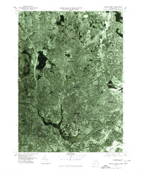
1977 Map of Boston North
USGS Topo · Published 1980About this map
The Mystic River serves as the central artery of this orthophotoquad, which captures the densely developed urban corridor north of Boston in the late 1970s. Unlike traditional line-drawn maps, this aerial imagery reveals the true density of neighborhoods in Somerville and Cambridge, showing the closely packed residential blocks and industrial zones that define the region. The view extends from the residential streets of Melrose and Malden in the north down to the piers and waterfront infrastructure of Boston Harbor. This specific survey, produced by the Department of the Interior, provides researchers with an exact visual record of the region's mid-century urban planning, including the complex highway and rail networks cutting through Everett and Chelsea just before the major redevelopment projects of the late 20th century.
Find a feature on this map
11 named features on this map. Tap any name to fly to it.
Don’t see what you’re looking for? This feature index may not catch every label — zoom into the map to look around manually.
Map Details
Editions of this 1977 Boston North Map
This is the sole edition of this map. No revisions or reprints were ever made.
Other maps of this area

1886 · Lawrence
USGS Topo · 1:62,500

1888 · Lawrence
USGS Topo · 1:62,500

1888 · Salem
USGS Topo · 1:62,500

1892 · Boston Bay
USGS Topo · 1:62,500

1893 · Salem
USGS Topo · 1:62,500

1893 · Boston
USGS Topo · 1:62,500

1893 · Lawrence
USGS Topo · 1:62,500

1903 · Boston
USGS Topo · 1:62,500

1903 · Boston Bay
USGS Topo · 1:62,500

1917 · Salem
USGS Topo · 1:62,500