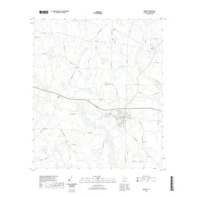
2020 Map of Boston
USGS Topo · Published 2020About this map
The Aucilla River meanders through the landscape west of Boston, where the town’s grid is defined by streets like W Garnett St and E Railroad Ave. This 2020 record of Thomas County captures a mix of agricultural land and wooded wetlands, with the Howell Sinks and Wildlife Pond indicating a complex local hydrology. Several family and community burial grounds, such as Mitchell Family Cem and Richland Cem, are scattered across the rural periphery, providing valuable touchstones for genealogists studying the area's legacy. Transportation is anchored by Old Hwy 84 W and the railway corridor, while smaller settlements like Eason are identified by their position along secondary routes such as Sally Rd. The map illustrates the persistent rural character of the region, where numerous named ponds and branches, including Turner Pond and Bailey Br, feed into the larger river system.
Find a feature on this map
82 named features on this map. Tap any name to fly to it.
Don’t see what you’re looking for? This feature index may not catch every label — zoom into the map to look around manually.
Map Details
Editions of this 2020 Boston Map
This is the sole edition of this map. No revisions or reprints were ever made.
Other maps of this area

1954 · Valdosta
USGS Topo · 1:250,000

1956 · Grooverville
USGS Topo · 1:24,000

1956 · Monticello NE
USGS Topo · 1:24,000

1956 · Metcalf
USGS Topo · 1:24,000

1957 · Thomasville
USGS Topo · 1:62,500

1958 · Valdosta
USGS Topo · 1:250,000

1959 · Valdosta
USGS Topo · 1:250,000

1961 · Quitman
USGS Topo · 1:62,500
1975 · Thomasville
USGS Topo · 1:24,000
1975 · Merrillville
USGS Topo · 1:24,000