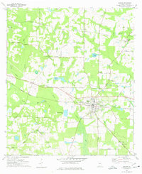
1977 Map of Boston
USGS Topo · Published 1978About this map
Boston sits as the central hub of this South Georgia landscape, where the Seaboard Coast Line railroad dictates the town’s orientation and growth. The surrounding countryside in Thomas County is defined by a dense network of country roads like Ozell Road and Moultrie Road, connecting a series of rural spiritual centers including St Josephs Ch, Antioch Ch, and Prospect Ch. The hydrology of the region is notably diverse, featuring the winding Aucilla River alongside curious geological formations such as Howell Sinks. Private and named water bodies like Massey-Ferguson Pond and Cambest Pond suggest a landscape managed for agriculture and timber. Genealogists will find significant value in the distribution of family and church burial grounds, from Williams Cem in the north to Centenary Cem in the southeast, providing a clear picture of local settlement patterns during the late 1970s.
Find a feature on this map
52 named features on this map. Tap any name to fly to it.
Don’t see what you’re looking for? This feature index may not catch every label — zoom into the map to look around manually.
Map Details
Editions of this 1977 Boston Map
This is the sole edition of this map. No revisions or reprints were ever made.
Other maps of this area

1954 · Valdosta
USGS Topo · 1:250,000

1956 · Grooverville
USGS Topo · 1:24,000

1956 · Monticello NE
USGS Topo · 1:24,000

1956 · Metcalf
USGS Topo · 1:24,000

1957 · Thomasville
USGS Topo · 1:62,500

1958 · Valdosta
USGS Topo · 1:250,000

1959 · Valdosta
USGS Topo · 1:250,000

1961 · Quitman
USGS Topo · 1:62,500
1975 · Thomasville
USGS Topo · 1:24,000
1975 · Merrillville
USGS Topo · 1:24,000