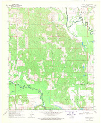
1969 Map of Boswell NW
USGS Topo · Published 1971About this map
Muddy Boggy Creek and Clear Boggy Creek dominate this 1969 landscape where the boundaries of Atoka, Bryan, and Choctaw counties converge. The terrain is a network of small water bodies and creek branches, supporting isolated rural settlements like Crystal and Boehler. The map provides a detailed view of community foundations in the late 1960s, including small country churches such as Crystal Ch, Myrtle Day Ch, and Pine Pole Ch. Genealogists may find particular value in the location of the Crystal Cem, while the various lakes like Atoka Lake, Boehler Lake, and Dobbins Lake illustrate the local hydrology and land use. The presence of Old Farris in the northern reaches and Sunkist to the east highlights a dispersed settlement pattern connected by light-duty roads and sections of the regional road network including the path toward Lane.
Find a feature on this map
34 named features on this map. Tap any name to fly to it.
Don’t see what you’re looking for? This feature index may not catch every label — zoom into the map to look around manually.
Map Details
Editions of this 1969 Boswell NW Map
This is the sole edition of this map. No revisions or reprints were ever made.
Other maps of this area

1899 · Atoka
USGS Topo · 1:125,000

1900 · Atoka
USGS Topo · 1:125,000

1901 · Antlers
USGS Topo · 1:125,000

1912 · Antlers
USGS Topo · 1:125,000

1925 · Antlers
USGS Topo · 1:125,000

1950 · Mcalester
USGS Topo · 1:250,000

1957 · Farris
USGS Topo · 1:24,000

1957 · Bruno
USGS Topo · 1:24,000

1957 · Lane
USGS Topo · 1:24,000

1957 · Ardmore
USGS Topo · 1:250,000