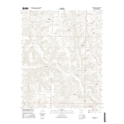
2017 Map of Botkinburg
USGS Topo · Published 2017About this map
Botkinburg and the nearby settlement of Rocky Hill anchor this upland reach of Van Buren County, where the terrain is defined by a dense network of ridges and hollows. The landscape is deeply carved by drainage systems including Archey Creek and Peyton Cr, with high points like Clinton Mtn and Crowell Mtn rising above the valleys. This area reveals a pattern of rural life tied to the local topography, evidenced by numerous family-named landmarks and cemeteries scattered across the ridges. Small family burial sites such as Lunceford Cem, Salem Cem, and Woolum Cem are prominent features, often located near old roadway intersections or on high ground. The presence of Jackson Lake and various named hollows like Zack Hollow suggests a history of localized water management and settlement within the sheltered areas between the major hills.
Find a feature on this map
73 named features on this map. Tap any name to fly to it.
Don’t see what you’re looking for? This feature index may not catch every label — zoom into the map to look around manually.
Map Details
Editions of this 2017 Botkinburg Map
This is the sole edition of this map. No revisions or reprints were ever made.
Other maps of this area

1892 · Marshall
USGS Topo · 1:125,000

1892 · Mountain View
USGS Topo · 1:125,000

1894 · Mountain View
USGS Topo · 1:125,000

1894 · Marshall
USGS Topo · 1:125,000

1901 · Marshall
USGS Topo · 1:125,000

1956 · Russellville
USGS Topo · 1:250,000
1962 · Canaan
USGS Topo · 1:24,000

1963 · Leslie
USGS Topo · 1:24,000

1964 · Russellville
USGS Topo · 1:250,000
1965 · Rex
USGS Topo · 1:24,000