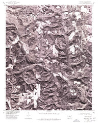
1976 Map of Botkinburg
USGS Topo · Published 1977About this map
Botkinburg and its surrounding uplands appear in this mid-1970s orthophotograph, which captures the distinct spatial patterns of north-central Arkansas. The landscape is defined by the winding valley of Archey Creek, where the narrow bottomlands provided the only level ground for agriculture and transit. In contrast to the densely forested slopes, the ridge tops near Rocky Hill show a mosaic of small clearings and homesteads, reflecting the enduring rural character of Van Buren County. Produced by the Geological Survey in cooperation with the Soil Conservation Service, this imagery records the intersection of rugged topography and human settlement just before the onset of modern development in the Ozark foothills.
Find a feature on this map
3 named features on this map. Tap any name to fly to it.
Don’t see what you’re looking for? This feature index may not catch every label — zoom into the map to look around manually.
Map Details
Editions of this 1976 Botkinburg Map
This is the sole edition of this map. No revisions or reprints were ever made.
Other maps of this area

1892 · Marshall
USGS Topo · 1:125,000

1892 · Mountain View
USGS Topo · 1:125,000

1894 · Mountain View
USGS Topo · 1:125,000

1894 · Marshall
USGS Topo · 1:125,000

1901 · Marshall
USGS Topo · 1:125,000

1956 · Russellville
USGS Topo · 1:250,000
1962 · Canaan
USGS Topo · 1:24,000

1963 · Leslie
USGS Topo · 1:24,000

1964 · Russellville
USGS Topo · 1:250,000
1965 · Rex
USGS Topo · 1:24,000