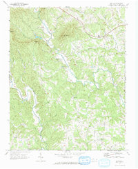
1971 Map of Bottom
USGS Topo · Published 1992About this map
Fisher River and the Mitchell River carve through the prominent peaks of the Blue Ridge foothills, defining a landscape of isolated mountain communities in the early 1970s. The terrain is anchored by significant elevations like Skull Camp Mtn and Raven Knob, with the settlement of Bottom situated at the confluence of several watercourses. This area of Surry County is characterized by a dense network of local institutions, evidenced by the numerous country churches such as Salem Fork Ch and New Bethel Ch. The presence of Blevins Store and the Beulah Sch suggests the persistence of traditional rural hubs, while the labeling of the Sewage Disposal facility near Bottom indicates the encroachment of modern infrastructure into this agricultural and upland environment. Genealogists will find interest in the various unnamed cemeteries scattered near Ladonia and other small crossroads.
Find a feature on this map
33 named features on this map. Tap any name to fly to it.
Don’t see what you’re looking for? This feature index may not catch every label — zoom into the map to look around manually.
Map Details
Editions of this 1971 Bottom Map
Other maps of this area

1889 · Hillsville
USGS Topo · 1:125,000

1891 · Yadkinville
USGS Topo · 1:125,000

1892 · Hillsville
USGS Topo · 1:125,000

1893 · Yadkinville
USGS Topo · 1:125,000

1896 · Hillsville
USGS Topo · 1:125,000

1931 · Galax
USGS Topo · 1:48,000

1933 · Galax
USGS Topo · 1:62,500

1953 · Winston-Salem
USGS Topo · 1:250,000

1955 · Winston-Salem
USGS Topo · 1:250,000

1957 · Mount Airy
USGS Topo · 1:62,500