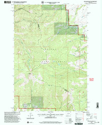
2001 Map of Boulder Baldy
USGS Topo · Published 2004About this map
Boulder Baldy and Boulder Mountain anchor this high-elevation landscape within the Helena National Forest, straddling the administrative boundary between Broadwater and Meagher counties. The terrain is defined by a dense network of drainages and seasonal water sources, including the headwaters of Confederate Gulch and Blacktail Creek. The map reveals a remote wilderness characterized by steep ridges and glacial features, such as Camas Lake and the Boulder Lakes.
Find a feature on this map
28 named features on this map. Tap any name to fly to it.
Don’t see what you’re looking for? This feature index may not catch every label — zoom into the map to look around manually.
Map Details
Editions of this 2001 Boulder Baldy Map
This is the sole edition of this map. No revisions or reprints were ever made.
Other maps of this area

1886 · Fort Logan
USGS Topo · 1:250,000

1948 · White Sulphur Springs
USGS Topo · 1:250,000

1950 · Duck Creek Pass
USGS Topo · 1:62,500

1958 · White Sulphur Springs
USGS Topo · 1:250,000

1961 · White Sulphur Springs
USGS Topo · 1:250,000

1965 · White Sulphur Springs
USGS Topo · 1:250,000

1966 · Boulder Baldy
USGS Topo · 1:24,000

1966 · Diamond City
USGS Topo · 1:24,000

1966 · Whites City
USGS Topo · 1:24,000

1966 · Watson
USGS Topo · 1:24,000