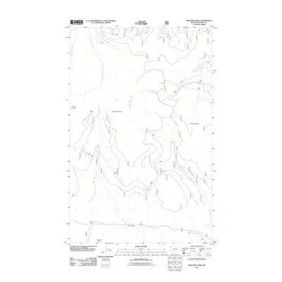
2011 Map of Boulder Lakes
USGS Topo · Published 2011About this map
Big Creek Cabin sits near the confluence of the North Fork Big Creek and South Fork Big Creek in this northern Montana landscape. The drainage system is the primary structural element of this terrain, with the Little North Fork and its namesake Little North Fork Falls cutting through the eastern slopes of Thirsty Mountain. The map detail follows the high ridges from Purcell Summit to Boulder Mountain, revealing a network of forest access routes like the Natl Forest Develop Road 7229 Rd that connect these remote peaks.
Find a feature on this map
19 named features on this map. Tap any name to fly to it.
Don’t see what you’re looking for? This feature index may not catch every label — zoom into the map to look around manually.
Map Details
Editions of this 2011 Boulder Lakes Map
This is the sole edition of this map. No revisions or reprints were ever made.
Other maps of this area

1957 · Kalispell
USGS Topo · 1:250,000

1960 · Kalispell
USGS Topo · 1:250,000

1961 · Kalispell
USGS Topo · 1:250,000

1963 · Robinson Mountain
USGS Topo · 1:24,000

1963 · Pink Mountain
USGS Topo · 1:24,000

1963 · Red Mountain
USGS Topo · 1:24,000

1963 · Webb Mountain
USGS Topo · 1:24,000

1963 · Boulder Lakes
USGS Topo · 1:24,000
1963 · Inch Mountain
USGS Topo · 1:24,000

1963 · Mount Henry
USGS Topo · 1:24,000