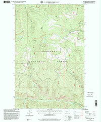
1997 Map of Boulder Lakes
USGS Topo · Published 2000About this map
Kootenai National Forest dominates this landscape in Lincoln County, where the high ridges of Purcell Summit and Boulder Mountain define the drainage patterns of the northern Rockies. The area serves as a critical watershed for the complex river systems of the region, featuring the headwaters of the North Fork Boulder Creek and the deep incisions of Knife Gulch. Human presence is minimal and focused on resource management, marked by the remote Big Creek Cabin and the Vinal Creek Trail which provides access through the timbered slopes. The geography is characterized by its high-elevation basins, most notably the Boulder Lakes, and the convergence of several major tributaries including the Little North Fork Big Creek and South Fork Big Creek. This 1997 revision highlights the intricate network of forest service roads and trails used for managing these protected public lands.
Find a feature on this map
19 named features on this map. Tap any name to fly to it.
Don’t see what you’re looking for? This feature index may not catch every label — zoom into the map to look around manually.
Map Details
Editions of this 1997 Boulder Lakes Map
This is the sole edition of this map. No revisions or reprints were ever made.
Other maps of this area

1957 · Kalispell
USGS Topo · 1:250,000

1960 · Kalispell
USGS Topo · 1:250,000

1961 · Kalispell
USGS Topo · 1:250,000

1963 · Robinson Mountain
USGS Topo · 1:24,000

1963 · Pink Mountain
USGS Topo · 1:24,000

1963 · Red Mountain
USGS Topo · 1:24,000

1963 · Webb Mountain
USGS Topo · 1:24,000

1963 · Boulder Lakes
USGS Topo · 1:24,000
1963 · Inch Mountain
USGS Topo · 1:24,000

1963 · Mount Henry
USGS Topo · 1:24,000