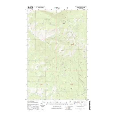
2017 Map of Boundary Mountain
USGS Topo · Published 2017About this map
Colville National Forest dominates this northern Washington terrain, characterized by a complex network of forest development roads and significant peaks near the international border. The landscape is defined by its drainages, including the various branches of Lone Ranch Creek and North Fork Day Creek, which carve through high elevations marked by Boundary Mountain and Togo Mountain. A notable feature for modern hikers is the Pacific NW National Scenic Trail, which traverses the eastern half of the quadrangle, passing near Noonday Spring and Marble Mountain. The infrastructure reflects active forest management and recreation, with named routes like the Summit Motor Way and Bardwell Loop providing access to the deep interior of the Kettle River Range foothills.
Find a feature on this map
40 named features on this map. Tap any name to fly to it.
Don’t see what you’re looking for? This feature index may not catch every label — zoom into the map to look around manually.
Map Details
Editions of this 2017 Boundary Mountain Map
This is the sole edition of this map. No revisions or reprints were ever made.
Other maps of this area

1904 · Republic
USGS Topo · 1:125,000

1936 · Marcus
USGS Topo · 1:96,000

1942 · Marcus
USGS Topo · 1:125,000

1948 · Curlew
USGS Topo · 1:62,500

1948 · Togo Mountain
USGS Topo · 1:62,500

1951 · Togo Mountain
USGS Topo · 1:62,500

1951 · Curlew
USGS Topo · 1:62,500

1954 · Okanogan
USGS Topo · 1:250,000

1958 · Okanogan
USGS Topo · 1:250,000
1983 · Bulldog Mtn
USGS Topo · 1:24,000