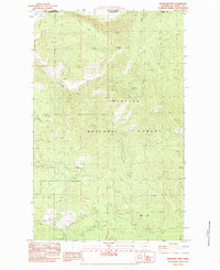
1983 Map of Boundary Mtn
USGS Topo · Published 1983About this map
The international border between Washington State and British Columbia dominates the northern reaches of this map, marked by a series of surveyor monuments including Bdy Mon 156 and Bdy Mon 158. Situated within the Colville National Forest in Ferry County, the landscape is defined by high ridgelines and the headwaters of numerous creeks. An Indian Allotment Bdy highlights early land divisions in the northwestern corner, while a lone Prospect on the western slope of Boundary Mtn points to the region's mineral exploration history. The terrain is a network of drainage systems, with North Fork Lone Ranch Creek and Togo Creek carving deep valleys between peaks like Togo Mountain and Green Mtn. This 1983 edition captures a remote mountain environment primarily accessed by 4WD tracks and forest trails.
Find a feature on this map
38 named features on this map. Tap any name to fly to it.
Don’t see what you’re looking for? This feature index may not catch every label — zoom into the map to look around manually.
Map Details
Editions of this 1983 Boundary Mtn Map
This is the sole edition of this map. No revisions or reprints were ever made.
Other maps of this area

1904 · Republic
USGS Topo · 1:125,000

1936 · Marcus
USGS Topo · 1:96,000

1942 · Marcus
USGS Topo · 1:125,000

1948 · Curlew
USGS Topo · 1:62,500

1948 · Togo Mountain
USGS Topo · 1:62,500

1951 · Togo Mountain
USGS Topo · 1:62,500

1951 · Curlew
USGS Topo · 1:62,500

1954 · Okanogan
USGS Topo · 1:250,000

1958 · Okanogan
USGS Topo · 1:250,000
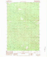
1983 · Bulldog Mtn
USGS Topo · 1:24,000