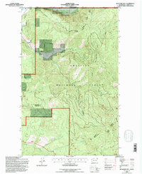
1992 Map of Boundary Mtn
USGS Topo · Published 1996About this map
The Canada United States border defines the northern edge of this high-elevation landscape in Ferry County, where the Colville National Forest encompasses a series of prominent peaks. Elevations rise from the Kettle River valley in the northwest corner toward several high summits including Boundary Mtn, Togo Mountain, and Green Mtn. This area is shaped by its drainage networks, with the North Fork Lone Ranch Creek and Day Creek carving through the terrain. A historical layer of land management is visible through the Indian Allotment Bdy designations along the western boundary, indicating specific land parcels within the larger forest context. Evidence of mineral exploration appears at a marked Prospect near the center of the quadrangle, while the southern reaches are defined by West Deer Creek and Dry Mtn.
Find a feature on this map
25 named features on this map. Tap any name to fly to it.
Don’t see what you’re looking for? This feature index may not catch every label — zoom into the map to look around manually.
Map Details
Editions of this 1992 Boundary Mtn Map
This is the sole edition of this map. No revisions or reprints were ever made.
Other maps of this area

1904 · Republic
USGS Topo · 1:125,000

1936 · Marcus
USGS Topo · 1:96,000

1942 · Marcus
USGS Topo · 1:125,000

1948 · Curlew
USGS Topo · 1:62,500

1948 · Togo Mountain
USGS Topo · 1:62,500

1951 · Togo Mountain
USGS Topo · 1:62,500

1951 · Curlew
USGS Topo · 1:62,500

1954 · Okanogan
USGS Topo · 1:250,000

1958 · Okanogan
USGS Topo · 1:250,000
1983 · Bulldog Mtn
USGS Topo · 1:24,000