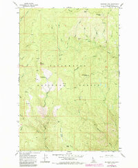
1966 Map of Boundary Peak
USGS Topo · Published 1984About this map
Boundary Peak and the high ridges of the Clearwater National Forest dominate this mid-century survey of central Idaho. The landscape is defined by a dense network of watercourses, including Eldorado Creek, Frenchman Creek, and the winding Canyon Creek, which carve deep valleys between peaks like Mex Mountain and Frenchman Butte. A system of historic routes, most notably the Lolo Trail and various pack trails, provides the primary means of traversal through this backcountry.
Find a feature on this map
50 named features on this map. Tap any name to fly to it.
Don’t see what you’re looking for? This feature index may not catch every label — zoom into the map to look around manually.
Map Details
Editions of this 1966 Boundary Peak Map
2 editions found
Other maps of this area

1911 · Lolo
USGS Topo · 1:250,000

1913 · Lolo
USGS Topo · 1:250,000

1924 · Weippe
USGS Topo · 1:125,000

1956 · Hamilton
USGS Topo · 1:250,000

1959 · Hamilton
USGS Topo · 1:250,000

1960 · Hamilton
USGS Topo · 1:250,000

1964 · Hamilton
USGS Topo · 1:250,000
1966 · Hemlock Butte
USGS Topo · 1:24,000

1966 · Lowell
USGS Topo · 1:24,000
1966 · Snowy Summit
USGS Topo · 1:24,000