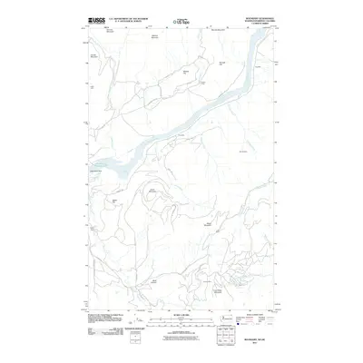
2011 Map of Boundary
USGS Topo · Published 2011About this map
The Columbia River flows through this northern Washington landscape, feeding into the expansive waters of Franklin D Roosevelt Lake. The terrain is defined by significant elevations such as Simons Mountain and Grass Mountain, while agricultural and industrial footprints appear in the form of the Lind Ranch and Melrose Mine. Evidence of early settlement and recreation is found at the Lutjen Cabin and Holiday Camp, suggesting a history of seasonal residence and resource extraction. Transport through the area relies on a network of local roads including Boundary Hwy and Aladdin Rd, which navigate between prominent geographical features like Steamboat Rock and the narrow passage of Black Canyon. This survey documents the intersection of water management at Ruby Dam with the natural drainage of numerous creeks such as Deep Creek and O'Hare Creek.
Find a feature on this map
42 named features on this map. Tap any name to fly to it.
Don’t see what you’re looking for? This feature index may not catch every label — zoom into the map to look around manually.
Map Details
Editions of this 2011 Boundary Map
This is the sole edition of this map. No revisions or reprints were ever made.
Other maps of this area

1929 · Colville
USGS Topo · 1:125,000

1933 · Colville
USGS Topo · 1:125,000

1952 · Spirit
USGS Topo · 1:24,000

1952 · Deep Lake
USGS Topo · 1:24,000

1952 · Leadpoint
USGS Topo · 1:24,000

1952 · Boundary
USGS Topo · 1:24,000

1958 · Sandpoint
USGS Topo · 1:250,000

1963 · Sandpoint
USGS Topo · 1:250,000
1969 · Onion Creek
USGS Topo · 1:24,000
1969 · Northport
USGS Topo · 1:24,000