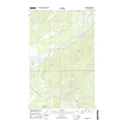
2017 Map of Boundary
USGS Topo · Published 2017About this map
The Columbia River flows through this northern Washington landscape, bordering the settlement of Boundary just south of the international line. This 2017 survey shows the river expanding into Franklin D Roosevelt Lake, where landmarks like Deadmans Eddy sit below the high peaks of Moraski Mtn and Mitchell Mtn. The terrain is defined by a mix of level plateaus such as Mitchell Flat and Becker Flat, which contrast with the steep drainage of Black Canyon. Genealogists and local historians can locate the Forest Home Cem near the southern boundary, while hikers can trace the winding route of the Pacific NW National Scenic Trail as it traverses the high ridges. Aviation history is noted by the presence of Schmidt Ranch Airport along Northport Waneta Rd, serving as a vital transport link in this mountain-and-river corridor.
Find a feature on this map
42 named features on this map. Tap any name to fly to it.
Don’t see what you’re looking for? This feature index may not catch every label — zoom into the map to look around manually.
Map Details
Editions of this 2017 Boundary Map
This is the sole edition of this map. No revisions or reprints were ever made.
Other maps of this area

1929 · Colville
USGS Topo · 1:125,000

1933 · Colville
USGS Topo · 1:125,000

1952 · Spirit
USGS Topo · 1:24,000

1952 · Deep Lake
USGS Topo · 1:24,000

1952 · Leadpoint
USGS Topo · 1:24,000

1952 · Boundary
USGS Topo · 1:24,000

1958 · Sandpoint
USGS Topo · 1:250,000

1963 · Sandpoint
USGS Topo · 1:250,000
1969 · Onion Creek
USGS Topo · 1:24,000
1969 · Northport
USGS Topo · 1:24,000