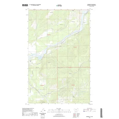
2020 Map of Boundary
USGS Topo · Published 2020About this map
The Columbia River flows through the northern reaches of Stevens County, marking a landscape where the river’s historical path meets the expansive waters of Franklin D Roosevelt Lake. This mountainous terrain is defined by significant elevations such as Mitchell Mtn, Moraski Mtn, and Lime Creek Mtn, which frame the narrow valleys and flats. Human presence is etched into the topography through a network of rural routes like Northport Waneta Rd and Aladdin Rd, serving isolated points of interest including the Schmidt Ranch Airport and the Forest Home Cem. The presence of the Pacific NW National Scenic Trail winding through the southern peaks suggests a transition from industrial and ranching uses to modern recreational conservation. Notable water features like Deadmans Eddy and the steep walls of Black Canyon indicate the geological intensity of the drainage basins feeding into the river system.
Find a feature on this map
44 named features on this map. Tap any name to fly to it.
Don’t see what you’re looking for? This feature index may not catch every label — zoom into the map to look around manually.
Map Details
Editions of this 2020 Boundary Map
This is the sole edition of this map. No revisions or reprints were ever made.
Other maps of this area

1929 · Colville
USGS Topo · 1:125,000

1933 · Colville
USGS Topo · 1:125,000

1952 · Spirit
USGS Topo · 1:24,000

1952 · Deep Lake
USGS Topo · 1:24,000

1952 · Leadpoint
USGS Topo · 1:24,000

1952 · Boundary
USGS Topo · 1:24,000

1958 · Sandpoint
USGS Topo · 1:250,000

1963 · Sandpoint
USGS Topo · 1:250,000
1969 · Onion Creek
USGS Topo · 1:24,000
1969 · Northport
USGS Topo · 1:24,000