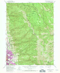
1952 Map of Bountiful Peak
USGS Topo · Published 1971About this map
Bountiful and Centerville sit at the foot of the Wasatch Range during a period of significant mid-century growth along the mountain front. This 1952 survey, with revisions from 1969, illustrates the expansion of residential blocks toward the steep eastern slopes where numerous drainage systems like Parrish Creek and Holbrook Creek emerge from deep canyons. The landscape is a mix of developing suburban centers and specialized mountain management, evidenced by the presence of the Farmington Research Center and Parrish Creek Research Center. Higher elevations are defined by recreational and administrative infrastructure, including Skyline Drive traversing the ridge near Bountiful Peak and the Farmington Guard Station. The map captures the interface between the dense grid of the Bountiful city boundary and the protected lands of the Wasatch National Forest.
Find a feature on this map
55 named features on this map. Tap any name to fly to it.
Don’t see what you’re looking for? This feature index may not catch every label — zoom into the map to look around manually.
Map Details
Editions of this 1952 Bountiful Peak Map
5 editions found
Other maps of this area

1885 · Salt Lake
USGS Topo · 1:250,000

1925 · Ft. Douglas
USGS Topo · 1:125,000

1928 · Ft. Douglas
USGS Topo · 1:125,000

1950 · Fort Douglas
USGS Topo · 1:24,000

1951 · Fort Douglas
USGS Topo · 1:24,000

1951 · Salt Lake City North
USGS Topo · 1:24,000

1952 · Farmington
USGS Topo · 1:24,000

1952 · Bountiful Peak
USGS Topo · 1:24,000

1954 · Salt Lake City
USGS Topo · 1:250,000

1954 · Ogden
USGS Topo · 1:250,000