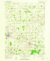
1958 Map of Bourbon
USGS Topo · Published 1976About this map
The town of Bourbon serves as a focal point for this late-1950s landscape, where a dense grid of section-line roads connects the agricultural interior of Marshall and Kosciusko Counties. To the southeast, Etna Green sits along the Pennsylvania Highway corridor, reflecting the importance of the railroad for these small Indiana communities. The geography is defined by a sophisticated network of drainage systems, such as Dausman Ditch, designed to manage the high water table of this fertile region, eventually feeding south toward the Tippecanoe River.
Find a feature on this map
71 named features on this map. Tap any name to fly to it.
Don’t see what you’re looking for? This feature index may not catch every label — zoom into the map to look around manually.
Map Details
Editions of this 1958 Bourbon Map
4 editions found
Other maps of this area

1953 · Fort Wayne
USGS Topo · 1:250,000

1953 · Chicago
USGS Topo · 1:250,000

1956 · Fort Wayne
USGS Topo · 1:250,000

1957 · Chicago
USGS Topo · 1:250,000

1957 · Inwood
USGS Topo · 1:24,000

1958 · Bremen
USGS Topo · 1:24,000

1958 · Nappanee West
USGS Topo · 1:24,000

1958 · Nappanee East
USGS Topo · 1:24,000

1958 · Bourbon
USGS Topo · 1:24,000

1959 · Atwood
USGS Topo · 1:24,000