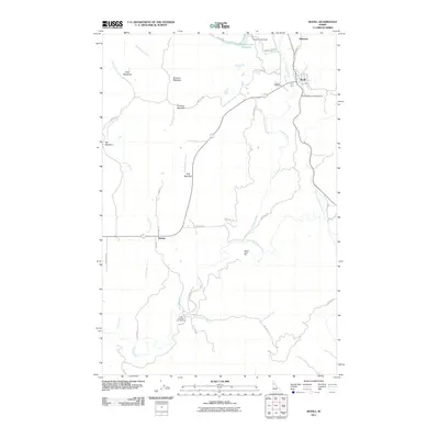
2011 Map of Bovill
USGS Topo · Published 2011About this map
Bovill serves as the primary hub in this corner of Latah County, situated near the headwaters of the Potlatch River and the East Fork Potlatch River. The landscape is a mosaic of open meadows and managed timberlands, where named clearings like Shea Meadows, Bronson Meadow, and Erickson Meadow interrupt the dense forest. Just south of town, the small community of Helmer sits along the road network near Hog Meadow, while to the north, Slabtown and the Bovill Cemetery mark the historic footprint of local settlement.
Find a feature on this map
38 named features on this map. Tap any name to fly to it.
Don’t see what you’re looking for? This feature index may not catch every label — zoom into the map to look around manually.
Map Details
Editions of this 2011 Bovill Map
This is the sole edition of this map. No revisions or reprints were ever made.
Other maps of this area

1955 · Pullman
USGS Topo · 1:250,000

1958 · Pullman
USGS Topo · 1:250,000

1961 · Deary
USGS Topo · 1:62,500

1961 · Kendrick
USGS Topo · 1:62,500

1961 · Ahsahka
USGS Topo · 1:62,500

1961 · Bovill
USGS Topo · 1:62,500

1981 · Potlatch
USGS Topo · 1:100,000
1990 · Bechtel Butte
USGS Topo · 1:24,000
1990 · Mc Gary Butte
USGS Topo · 1:24,000
1990 · Texas Ridge
USGS Topo · 1:24,000