
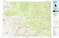
1981 Map of Potlatch
USGS Topo · Published 1982About this map
St Joe National Forest dominates the northern reaches of this 1981 survey, where the rugged timberlands give way to the agricultural heart of the Palouse Range. The map documents a critical intersection of Idaho's extractive and farming economies, centered around the company-town history of Potlatch and the institutional hub of Moscow. The rail network of the Burlington Northern serves as the primary spine for these communities, connecting timber centers like Bovill and Deary with the Clearwater River basin.
Find a feature on this map
73 named features on this map. Tap any name to fly to it.
Don’t see what you’re looking for? This feature index may not catch every label — zoom into the map to look around manually.
Map Details
Editions of this 1981 Potlatch Map
2 editions found
Other maps of this area

1903 · Oakesdale
USGS Topo · 1:125,000

1905 · Oakesdale
USGS Topo · 1:125,000

1910 · Pullman
USGS Topo · 1:125,000

1914 · Avery
USGS Topo · 1:125,000

1917 · Avery
USGS Topo · 1:125,000

1923 · Washington Creek
USGS Topo · 1:125,000

1924 · Kamiah
USGS Topo · 1:125,000

1924 · Weippe
USGS Topo · 1:125,000

1936 · Boehls Butte
USGS Topo · 1:48,000

1938 · Headquarters
USGS Topo · 1:48,000