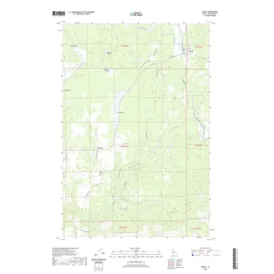
2020 Map of Bovill
USGS Topo · Published 2020About this map
The timber and transit history of Latah County is central to this 2020 map of Bovill and the surrounding Idaho forest. This area was historically shaped by the logging industry, as evidenced by the namesake Railroad Ave and the proximity of the Potlatch River. The small settlement of Helmer sits to the southwest, connected by a network of forest development roads such as Forks Rd and Nat For Dev Rd 1963.
Find a feature on this map
44 named features on this map. Tap any name to fly to it.
Don’t see what you’re looking for? This feature index may not catch every label — zoom into the map to look around manually.
Map Details
Editions of this 2020 Bovill Map
This is the sole edition of this map. No revisions or reprints were ever made.
Other maps of this area

1955 · Pullman
USGS Topo · 1:250,000

1958 · Pullman
USGS Topo · 1:250,000

1961 · Deary
USGS Topo · 1:62,500

1961 · Kendrick
USGS Topo · 1:62,500

1961 · Ahsahka
USGS Topo · 1:62,500

1961 · Bovill
USGS Topo · 1:62,500

1981 · Potlatch
USGS Topo · 1:100,000
1990 · Bechtel Butte
USGS Topo · 1:24,000
1990 · Mc Gary Butte
USGS Topo · 1:24,000
1990 · Texas Ridge
USGS Topo · 1:24,000