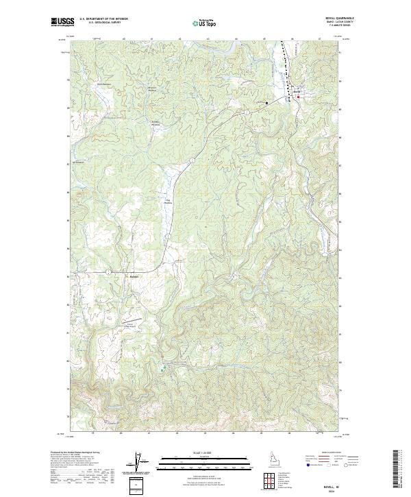
2024 Map of Bovill
USGS Topo · Published 2024About this map
The Potlatch River and its numerous tributaries, including the East Fork Potlatch River and Little Boulder Creek, carve through this section of Latah County, defining a landscape dominated by extensive meadowlands and forest. The settlement of Bovill serves as a primary hub in the northeast, where the Potlatch River meets Moose Creek. To the west, the smaller community of Helmer sits at the junction of Forks Rd and Helmer Ln, surrounded by high-elevation clearings such as Shea Meadows, Bronson Meadow, and Tee Meadow. This area highlights the transition from river valleys to upland meadows, with the Corral Creek Airport providing a distinct landing point south of Helmer. Genealogists may find interest in the Bovill Cem, located just west of the Bovill townsite, while the intricate network of forest roads, such as Palouse Divide Rd, suggests a long history of timber management and resource access throughout the drainage basins.
Find a feature on this map
44 named features on this map. Tap any name to fly to it.
Don’t see what you’re looking for? This feature index may not catch every label — zoom into the map to look around manually.
Map Details
Editions of this 2024 Bovill Map
This is the sole edition of this map. No revisions or reprints were ever made.
Other maps of this area

1955 · Pullman
USGS Topo · 1:250,000

1958 · Pullman
USGS Topo · 1:250,000

1961 · Deary
USGS Topo · 1:62,500

1961 · Kendrick
USGS Topo · 1:62,500

1961 · Ahsahka
USGS Topo · 1:62,500

1961 · Bovill
USGS Topo · 1:62,500

1981 · Potlatch
USGS Topo · 1:100,000
1990 · Bechtel Butte
USGS Topo · 1:24,000
1990 · Mc Gary Butte
USGS Topo · 1:24,000
1990 · Texas Ridge
USGS Topo · 1:24,000