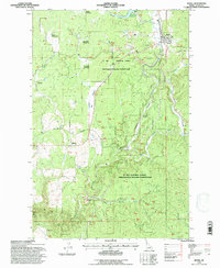
1994 Map of Bovill
USGS Topo · Published 1997About this map
Bovill serves as a central hub for the logging and resource extraction industry within the St Joe National Forest during the mid-1990s. The landscape is defined by the winding Potlatch River and its tributaries, such as Hog Meadow Creek and Little Boulder Creek, which carve through a series of significant openings including Moose Meadows and Shea Meadows. Industrial markers are scattered throughout the forest, with several Clay Pits, Gravel Pits, and areas of Tailings indicating the area's geological utility.
Find a feature on this map
26 named features on this map. Tap any name to fly to it.
Don’t see what you’re looking for? This feature index may not catch every label — zoom into the map to look around manually.
Map Details
Editions of this 1994 Bovill Map
This is the sole edition of this map. No revisions or reprints were ever made.
Other maps of this area

1955 · Pullman
USGS Topo · 1:250,000

1958 · Pullman
USGS Topo · 1:250,000

1961 · Deary
USGS Topo · 1:62,500

1961 · Kendrick
USGS Topo · 1:62,500

1961 · Ahsahka
USGS Topo · 1:62,500

1961 · Bovill
USGS Topo · 1:62,500

1981 · Potlatch
USGS Topo · 1:100,000
1990 · Bechtel Butte
USGS Topo · 1:24,000
1990 · Mc Gary Butte
USGS Topo · 1:24,000
1990 · Texas Ridge
USGS Topo · 1:24,000